The Galapagos Islands – Heart Warming and Adventurous

Giant Galapagos tortoises roaming freely in the lush highlands of Santa Cruz Island.

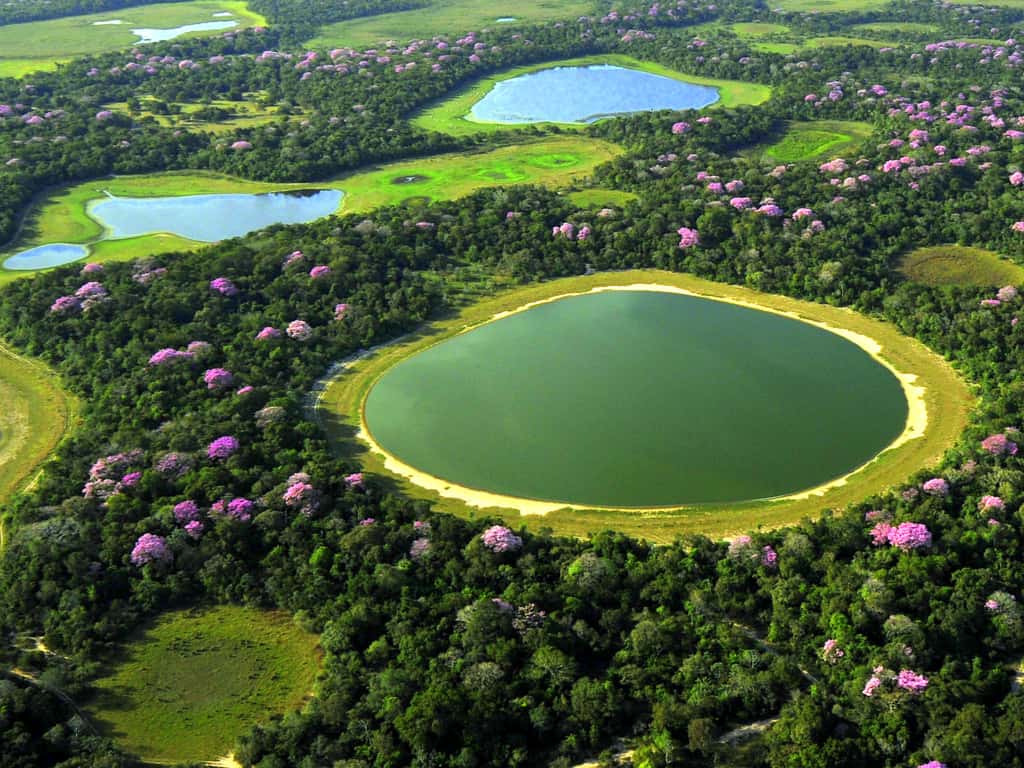
The Galapagos Islands are a group of isolated volcanic islands and tiny islets sprinkled in the Pacific Ocean. Friendly wildlife along with the scenic beauty of this archipelago is responsible for its top position in most bucket lists.

Galapagos Islands Animals – your pals during your Galapagos Holidays

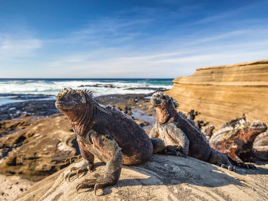
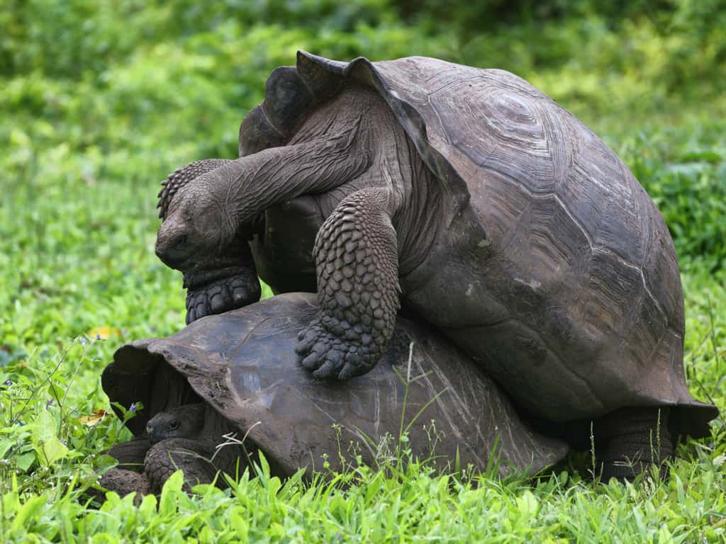
Thanks to its remote location and equatorial position in the Pacific, the Galapagos Islands harbors magnificent flora and unique wildlife. The vivid ecosystem of the Galapagos Islands had inspired Charles Darwin’s theory of Evolution.

A mother seal and her pup resting on the rocky shores of the Galapagos, a tender natural moment.
Witness the tender moment between a mother seal and her pup on the rocky shores of the Galapagos Islands.

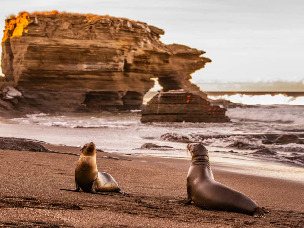
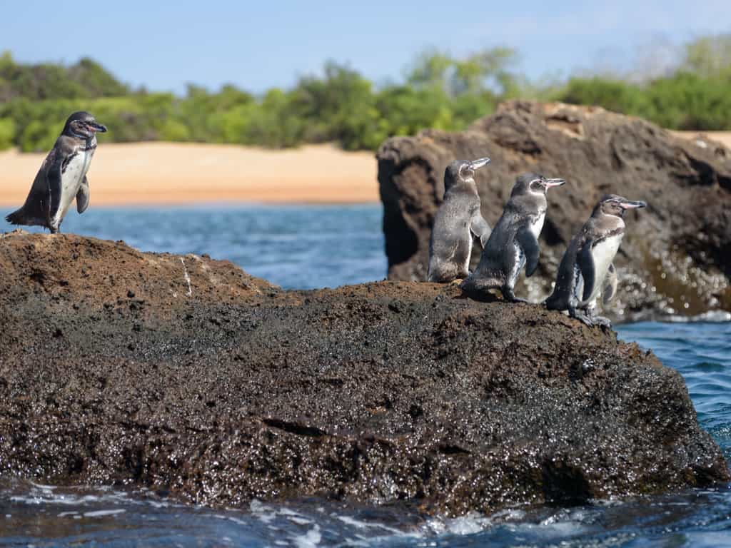
Not to forget, the beloved, adorable, and incredibly friendly Galapagos Sea lions are another major attraction along with the quiet and peaceful Galapagos fur seals. The only category of penguins to live in the north of the equator, the Galapagos penguins are a very rare sight to see – consider yourself fortunate if you do.

It is impossible to mention all these lovelies in one go, from bottlenose dolphins to golden stingrays, blue-footed boobies and albatross; oh my!

How many Galapagos Islands are there?

There are about 130 islands, of which 13 are larger and four are smaller islands above Galapagos hotspot.

The first islands formed here at least 8 million years ago, but possibly much earlier. While the older islands have eroded over time and disappeared back into the sea.

A Galapagos penguin swimming gracefully near Isabela Island, a rare sight in the tropical region.
Spot the rare Galapagos penguin swimming near Isabela Island, a unique encounter in this tropical paradise.

However, the approximately 25,000 inhabitants are only found on the five inhabited Galapagos Islands:

San Cristobal with the port Puerto Baquerizo Moreno which is also the provincial capital with 8.000 inhabitants;

Santa Cruz with the largest city of the archipelago, Puerto Ayora and 15.000 inhabitants;

Isabela with the port Puerto Villamil and 2.000 inhabitants;

Floreana with the port Puerto Velasco Ibarra and 120 inhabitants;

Baltra Island, where there is an airport and a small naval station.

Another 17 islands of the archipelago can be visited extensively during a Galapagos trip or cruise.

How to get to the Galapagos Islands?

First of all, you need to arrive at the mainland of Ecuador by landing either at Guayaquil or the capital city of Quito – Guayaquil’s Jose Joaquin de Olmedo International Airport or Quito’s Mariscal Sucre International Airport. Guayaquil seems to be more convenient for most travelers.

Most tours and cruises start from Santa Cruz Island. So you got to fly to Baltra Island first, from Quito or Guayaquil and then take a scenic ferry ride to Santa Cruz Island. It’s now time to head on to your tour.

Marine iguanas basking on the sun-drenched rocks of the Galapagos shoreline.
Marvel at the unique sight of marine iguanas sunbathing on the rocky shores of the Galapagos, a distinctive feature of the islands.

What to do at the Galapagos Islands?

You have to get your hands on Galapagos Island tours, months before your journey. They are high on demand and sell off really fast. They must include the following:

  • Snorkeling and diving.
  • Wildlife watching
  • Hiking – who wouldn’t want to trek over dried lava beds!
  • Kayaking – rent out a kayak at Tortuga Bay, Santa Cruz, you don’t even need a guide for this
  • Volunteer for some eco-friendly activities like farming and habitat restoration campaigns

The Galapagos holidays are a dream adventure for many travelers out there. Take a few days off and spend some wonderful time with friends or family, exploring the diversity of the group of islands.

Giant Galapagos tortoises roaming freely in the lush highlands of Santa Cruz Island.
Encounter the iconic giant Galapagos tortoises in their natural habitat on Santa Cruz Island, a highlight of Galapagos wildlife.

Where to stay when visiting the Galapagos Islands?

You might have to spend quite a few days here since there is so much to explore and enjoy. Below are our top recommendations for a comfortable stay at the Galapagos Islands.

Albemarle – Simple beachfront lodging, with antique wooden ceilings and a swimming pool area.

Royal Palm Galapagos – Perfect for a relaxing and exotic night stay.

Galapagos Morning Glory – Apart from the beachfront view, it gives access to a commercial area featuring stalls and banks.

Angermeyer Waterfront Inn – Minutes of walking away from the shore, and has an elegant design.

Villa Escalesia – Stunning villa with your very own private outdoor pool. Situated directly at the beach, providing a landscape view of a vast stretch of the Pacific.

Bonito Brazil – The Hidden Gem for Eco-Tourism

Tourists enjoying a tranquil boat ride on the serene waters of Bonito’s rivers, surrounded by untouched nature.

The turquoise-blue water, the untouched green woods, the species of animals in the forest, and the amazing environment, creates a magical and fascinating experience at Bonito Brazil. Keep reading this article ahead to know everything about this amazing place, we have included a complete guide of this location.

The natural essence of the beautiful eco-tourism locked in the southwestern corner of Mato Grosso do of Amazon Basin is breathtaking.

With the crystal clear water for diving, and snorkeling the Bonito is ethereal. The caves with lakes, beautiful waterfalls, and incredibly clear rivers, let us take a dip in the water to explore the mystical and ethereal secret paradise of Bonito in Brazil.

Where is Bonito Brazil?

The astonishing and mesmerizing Brazil’s Bonito is the nature’s paradise located in the southwestern corner of Mato Grosso do of Amazon Basin. With the crystal clear freshwater, the amazing and untouched green woods, the never-ending beauty of nature, and the amazing and rare animals to see, this place is a paradise of hues of blue and green.

A scenic waterfall cascading into a clear pool in Bonito, inviting visitors for a refreshing swim.
Cool off under a cascading waterfall in Bonito, an invigorating and refreshing experience in Brazil’s natural oasis.

How to get to Bonito Brazil?

Bonito in Brazil is undoubtedly the best eco-tourism destination and is heaven on earth. The best way and easiest way to reach Bonito in Brazil is via Campo Grande International Airport. It is located in the capital of Mato Grosso do Sul state. Fly from Rio to Bonito Brazil, first at the capital city of Campo, and then from there, you can book a private car to bust to reach the mesmerizing city of Bonito.

The mesmerizing Gruta do Lago Azul in Bonito, with its striking blue waters and ancient stalactites.
Discover the surreal beauty of Gruta do Lago Azul in Bonito, a cave with stunning blue waters and dramatic stalactites.

What to do in Bonito Brazil?

The mystical and magical turquoise-blue water is so charming, and the evergreen forest beside it makes it even more beautiful. With the splendid environment and the untouched greenery, Bonito in Brazil is heaven on earth.

The best things to do in Bonito Brazil are:

  • Go for snorkeling and diving in freshwater.
  • Go for a hike in waterfalls
  • Get thrilled by the rappelling and zip line
  • Try horseback riding in the green
  • Take a sip of Taboa, the typical strong spirit of Bonito
  • Explore the caves of Abismo Anhumas
  • Visit Boca da Onca and Estancia Mimosa
  • Try to Stand up Paddleboarding
  • Go for a bike ride on the trails
Crystal clear waters of the Rio da Prata in Bonito, Brazil, teeming with vibrant fish and aquatic plants.
Snorkel in the crystal clear waters of Rio da Prata in Bonito, Brazil, for an unforgettable encounter with diverse aquatic life.

When to visit Bonito Brazil?

To enjoy the mystical and magical environment, the amazing blue water, the best time to visit is between the months of April to September. With moderate temperature and low humidity, the experience during this period is just bliss.

With the amazing beauty of the water and the mystical green forest, the land is sheer paradise. The hidden gem which untouched and unadulterated is really one of the best places to pay your visit. With so much to love and explore, Bonito is flabbergasting. So to get butterflies in your stomach when you see beautiful Bonito, Brazil, why not plan a trip today!

Tourists enjoying a tranquil boat ride on the serene waters of Bonito’s rivers, surrounded by untouched nature.
Embark on a peaceful boat ride along Bonito’s rivers, a serene way to explore Brazil’s natural beauty.

Where to stay when visiting Bonito in Brazil?

With the alluring nature and the soothing water, this place is a mystical paradise. Visiting Brazil, Bonito is a magical experience. With the flabbergasting stay arrangements and the awesome environment, the times spent here turns magical.

The best places to stay here are:

Pousada Boyra: On the margins of Formoso River, this luxurious hotel is just classy with the outdoor pool, garden, terrace, and bar.

Bonito Ecotel: Just 8 km from Natural Aquarium, Bonito Ecotel offers the best in stay facilities and that in the budget.

CLH Suites Bonito: Offering both an adult and a children’s outdoor pool, CLH Suites Bonito is located at a distance of 100 m from Bonito’s central square and offers the best in class services.

Hotel Da Praca: The budget-friendly hotel with all the basic facilities is ready to amaze you with a pool and hot tub on the rooftop.

Atacama Desert – See The Most Flattest Place On Earth

A hand in the sand, inspired by the natural surroundings of the Atacama Desert

The Atacama Desert is an arid yet cool area, which covers 990-mile long land in northern Chile. It is arguably the driest place on earth and has been widely compared to Mars due to its diverse geological formations. NASA has been using the Atacama Desert as a research area for several years and major movies such as Space Odyssey. Voyage to the Planets have been filmed here.

Let’s explore this wondrous otherworldly region in a little more detail

Where is the Atacama Desert?

The Atacama Desert is present in the western direction of the Andes mountain range on the Pacific coast. More specifically, it is located between the mountains that demarcate the drainage basin of Salado-Copiapó and the southern end of Loa River. While Cordillera de la Costa is present on the desert’s western side, its eastern side has the Cordillera Domeyko or the Andes foothills. The topography of the Atacama Desert mainly comprises salt pans, alluvial fans, pebble accumulations, and dunes.

The vast, arid expanse of the Atacama Desert under a clear blue sky, embodying tranquility.
Experience the vastness and tranquility of the Atacama Desert, a serene escape into nature’s beauty.

Why is the Atacama Desert so dry?

The Atacama Desert Chile is the driest place on earth due to the high-pressure cell in the South Pacific region. The Humboldt or Peru Current also contributes to the hyper aridity by facilitating the upward movement of water from the oceanic depths. This cold water, in turn, results in thermal inversion wherein warmer air is present in elevated areas and colder air is located at sea level. Consequently, stratus clouds and fog are formed without any likelihood of rain.

Silhouette of a deer seen through the fingers of an outstretched hand at sunset in the Atacama Desert.
Capture the silhouette of a desert deer through an artistic perspective with your hand against the backdrop of an Atacama sunset.

Moreover, moisture advection is prevented due to Atacama Desert’s location between two mountain ranges, namely, the Chilean Coast Range and the Andes Mountains. Contrary to popular opinion, however, the Atacama Desert temperatures are quite low, soaring to 19 degrees Celsius in the summer months.

What is the best time to visit the Atacama Desert?

Although the weather at the Atacama Desert is largely determined by the Bolivian Andes, it is an all-year-round travel destination. The sun is bright during the day and the nights are resplendent with sparkling stars.

However, occasionally heavy rainfall is perceived between January and February while snow prevents crossings from the Atacama Desert to Argentina and Bolivia due to snowfall between June and September. So, you might want to avoid traveling to this region during this time period.

Flamingos wading in the Chaxa Lagoon in the Atacama Desert, showcasing the region's diverse wildlife.
“Discover the diverse wildlife of the Atacama Desert at the Chaxa Lagoon, home to beautiful flamingos.

Top 3 Facts about this unique place

Take a look at the top 3 mind-boggling facts about the Atacama Desert:

Archaeological Wonder: The earliest mummified human was first discovered in the Atacama Desert in 7020 BC, predating the Egyptian discovery by several thousand years.

Habitable or Not? The desert aridity does not stop the Atacama Desert from being inhabited by one million people who have established a home base in oasis towns, fishing villages as well as mining regions.

Astronomical Haven: The famous European Southern Observatory is located within the Atacama Desert. The dry weather conditions and high altitude make this desert a perfect place for stargazing.

A hand in the sand, inspired by the natural surroundings of the Atacama Desert
Experience a respectful encounter in the Atacama Desert, a gentle touch bridging nature and humanity.

Now that you are equipped with all the information you need about this unique dessert, start creating your travel plans to Mars on earth already!

Ruins of Tikal – The amazing Mayan architecture wonder

Majestic Temple I at the ruins of Tikal towering over the lush Guatemalan jungle

Tikal harbors are a complex of Mayan Ruins deep inside the rainforests of northern Guatemala. A couple of buildings in Tikal date back to as early as the fourth century B.C.

If you have a thing for historical city ruins and ancient architecture, the Mayan Ruins of Guametala shall probably be the best option to conjure upon.

Where are the Mayan Ruins of Tikal?

To be precise, these ruins are located in North Central Petén in Guatemala, around 50 miles to the northwest of its border with Belize. Tikal or YaxMutal is the largest, as well as the oldest of the many Maya cities.

Hikers exploring the jungle trails leading to the remote temples of Tikal
Embark on a jungle adventure to uncover the less-explored temples on your visit to the ruins of Tikal.

Why was Tikal so important to Mayans?

Archaeologists state that Tikal was the capital of a large conquest state, which was once one of the most powerful kingdoms in ancient Maya. During the Classic Period, this city dominated most of the Mesoamerican lands politically, militarily as well as economically.

Why is Mayan architecture special?

The area encompasses at least 3,000 buildings, which also include some very tall temples that manage to surpass the heights reached by the tall, thick canopy jungle!

Its impressive architecture comprises nine groups of courts along with plazas, interconnected with the help of bridges and pathways.

The ancient World Heritage site of Tikal at dusk, with temples silhouetted against the sky
Witness the enchanting beauty of Tikal at dusk, a UNESCO World Heritage site, during your visit.

What are the most notable attractions?

You should definitely not miss visiting the following places:

  • The Great Plaza – the main central square in the city.
  • The Central Acropolis – The mighty palace housing the major rulers of the city.
  • The North AcropolisThe MundoPerdido – a large Mayan Pyramid that served as a temple.
  • The Temple of Ah Cacao (Temple of the Great Jaguar) – is again a large pyramid that was used to be a burial site.
  • Temple I – It’s image is used in the currency notes of Guatemala.

The Mayans built these magnificent structures out of limestone, imparting strength, and durability to them.

Aerial view of Tikal National Park, with the ruins emerging from the dense jungle
Get an aerial perspective of Tikal National Park and its hidden ruins during your visit.

Furthermore, there is evidence of a system of paved causeways called the ‘Sacbeobs’ along with a thoughtfully designed network of canals. The canals were destined to capture falling rainwater and feed it all to the city’s water reservoirs. In addition to these, they also found ruins of ball courts that were used to play the Mesoamerican ballgame.

Unfortunately, the city was gradually abandoned because people started facing overpopulation and crop failure issues, which in turn led to hunger and suffering. To add to that, the city is believed to be hit by numerous natural calamities over and over again. A multitude of reasons explains the falling of this majestic city into mere ruins.

Majestic Temple I at the ruins of Tikal towering over the lush Guatemalan jungle
Witness the iconic Temple I during your visit to the ruins of Tikal, a marvel of ancient Mayan architecture.

Facts about the Mayan Ruins in Guatemala

There is evidence of early agricultural activity and remains of ceramics. Archaeologists have discovered the burial sites of prominent leaders of the era.

As of 1979, the Mayan Ruins of Guametala have declared a UNESCO World Heritage Site, and why not!

In addition to its various well-excavated courts, temples, and pyramids, Tikal further fascinates tourists by providing them with an excellent opportunity to watch birds and animals. You are bound to find some new friends along your paths – Spiders, Howler monkeys, gray foxes, and red coatis. You just can’t get more pleased with your visit to the Mayan Ruins in Guatemala.

Machu Picchu – Trip to the marvelous Inca architecture

The iconic Sun Gate at Machu Picchu, offering a breathtaking entrance to the ancient city with stunning mountain views

The stone city of Machu Picchu is by far a fascinating archaeological site in Peru. It is a testament of power and ingenuity of the Inca people, one of South America’s largest ancient empires.

Built around the mid-fifteenth century, Machu Picchu is one of the few well-preserved remnants of the Inca civilization.

What is Machu Picchu, and who built them?

Machu Picchu is a striking example of the Inca’s engineering feat. The Inca people constructed Machu Picchu’s palaces, terraces, temples, plazas, and the infrastructure using only stones.

Mind you, they didn’t use any metal tools, wheels, or mortar while building these structures.

Nonetheless, the stones of Machu Picchu buildings are so sharply and precisely cut that they snuggly fit into one another, even after forgoing the use of mortar. You just can’t separate two rocks.

Panoramic view of the ancient Incan city of Machu Picchu, nestled in the Peruvian Andes, under a clear blue sky
Explore the majestic ruins of Machu Picchu, a testament to Incan ingenuity, set high in the Peruvian Andes.

Another thing to note is that the location of Machu Picchu is between two fault plates. This factor makes it prone to damage due to earthquakes. The stones’ unique cut and fit, make sure that they bounce back to their original position after shaking. These engineering marvels have managed to preserve Machu Picchu for over 500 years.

Why it was built, you may ask. Its purpose is still a mystery to many archaeologists. These human-made structures seem to align perfectly with certain astrological events. However, all of a sudden, in the sixteenth century, Machu Picchu was abandoned.

Stone structures of Machu Picchu with Huayna Picchu mountain in the backdrop, illustrating the harmony between Incan architecture and nature
Marvel at the harmony of ancient Incan architecture with the natural landscape, with Huayna Picchu towering over Machu Picchu.

Who discovered Machu Picchu?

Archaeologists couldn’t configure the purpose of the site since the Incas had no written language. It was long isolated and unnoticed until Hiram Bingham, an American archaeologist, discovered it in 1911.

How to get to Machu Picchu?

Below are our recommendations for routes from Lima to Machu Picchu. First, get to Cusco from Lima by plane or the Peru Hop bus. Then you may choose any of the following :

  • If you have a tight schedule, you can go by train: Get on a train from Cusco, followed by a bus ride to the entrance of the ruins.
  • But if you want to enjoy your travel to the fullest, keep four days in hand and follow the classic Inca trail. Trek all the way, and explore some picturesque spots on your ways such as Phuyupatamarca and WinyaWayna.
Close-up of the intricate stone walls of Machu Picchu, displaying the Incas' advanced masonry skills
Admire the intricate stone walls of Machu Picchu, a testament to the Incas’ advanced masonry skills.

How much does it cost to get there?

The entry ticket costs somewhere around $60-80. If you travel with minimal expenditure, by trekking and bus and stay in the cheapest of hotels, you are bound to spend $250 on the entire trip. At the same time, the average expense of a Machu Picchu trip, including flights to food, may go up to around $550.

What is the best time to visit Machu Picchu?

We recommend booking your Machu Picchu tours for October, as the weather is pleasant and you get to face the little crowd.

The iconic Sun Gate at Machu Picchu, offering a breathtaking entrance to the ancient city with stunning mountain views
Witness the breathtaking views from the Sun Gate, the historic entrance to the wonders of Machu Picchu.

Where to stay when visiting this ancient Inca place?

In 1983, Machu Picchu got the title of the UNESCO World Heritage site, and since then, it has attracted millions of tourists each year. Located more than 7,000 feet above the sea level on the mighty Andes Mountains, this marvelous symbol of the Incan empire was designated as one of the Seven Wonders of the World in 2007.

Easter Island – Exposition of hidden treasures amidst the Pacific

Close-up of the intricate carvings on a moai statue on Easter Island, reflecting the skill of the ancient Rapa Nui people

Searching for a unique travel destination for your next trip? Your search ends here. Rapa Nui National Park & Easter Island are located in the Pacific Ocean, approximately two thousand miles away from South America. Rapa Nui National Park comprises approximately 42 percent of Easter Island.

This destination is a part of the Polynesian triangle along with New Zealand and Hawaii. The 900 monumental sculptures of Easter Island have made this a major travel destination.

How to get to Easter Island?

Tourists dedicate two days to travel to Easter Island. You will have to travel to Santiago, the Chilean capital, first. LAN Airlines offer six-hour one flight from Santiago to Easter Island on a regular basis. The approximate travel time is around one and a half days.

Close-up of the intricate carvings on a moai statue on Easter Island, reflecting the skill of the ancient Rapa Nui people

How much does it cost to go to Easter Island?

You can gain access to Rapa Nui National Park by buying a ticket worth 80 dollars at the National Park booth at Mataveri Airport. Alternatively, tickets are also available at Ma’u Henua Indigenous Community Central Office in Hanga Roa.

The ticket facilitates you with an entry in Rano Kau Quarry and Ahu Tongariki. We promise that the experience is worth it and justifies the slightly higher entrance fee.

Sunset casting a golden glow over the moai statues at Ahu Tongariki on Easter Island, creating a mystical atmosphere
Witness the captivating sunset at Ahu Tongariki, where the moai statues of Easter Island are bathed in golden light.

Why is Easter Island called Easter Island?

It’s time for a history lesson. Contrary to popular opinion, Jacob Roggeveen – a Dutch explorer – discovered this eponymous island while sailing south Pacific on April 5, 1722.

This date coincided with the Easter holiday, according to the Christian calendar. Feeling inspired, Jacob named this island ‘Paasch-Eyland’, which stands for ‘Easter Island’ in Dutch. Isn’t this Easter Island fact mesmerizing?

The Top 3 Easter Island Facts

  1. Easter Island was the first Pacific island nation to be classified as a UNESCO World Heritage Site.
  2. None of the monumental sculptures of Easter Island were erect when they were first discovered. The ones you see today have been re-erected.
  3. The statues are believed to harbor spirits of tribal ancestors. They are perceived as the symbol of good fortune by locals.
The serene Anakena Beach on Easter Island, with its white sands and moai statues overlooking the Pacific Ocean
Relax on the pristine Anakena Beach of Easter Island, a perfect blend of historical intrigue and tropical beauty.

What is the best time to visit Rapa Nui National Park & Easter Island?

The best possible time of the year when you should visit Rapa Nui National Park & Easter Island is between October and December and April and June. The temperate climate makes sightseeing easy and the prices are quite reasonable.

If you wish to attend the Tapati Rapa Nui Festival, you will have to visit during February. The cool ocean breeze effortlessly complements the tropical weather, thereby making tourism comfortable.

However, the temperatures can sometimes exceed 27 degrees Celsius, so make sure that you carry ample water and apply sunscreen.

"Iconic moai statues standing against a backdrop of a clear blue sky on Easter Island, a symbol of the island's mysterious past
Explore the enigmatic moai statues of Easter Island, a testament to the island’s rich and mysterious history.

Where should you stay in Rapa Nui National Park & Easter Island?

Hare Nua Hotel Boutique: Provides the coziest rooms filled with greens and antique straw furniture, with a traditional wooden bathtub to calm your nerves at the end of your adventures.

Hotel Maea Hare Repa: The choice for minimalistic and comfortable accommodation and delicious breakfast buffet.

Pikera Uri Eco Lodge: Classy and vintage with a mesmerizing ocean view, it never fails to please the visitors.

Inaki Uhi Hotel: One of our top picks, thanks to its convenient location along with its homely feel and highly co-operative and gentle staff.

Hotel Hangaroa Eco Village & Spa: Fantastic service and celebrity style treatment right on the seashore! Also, it is at a walkable distance from the Hanga Roa.

Salar de Uyuni – Find yourself in the World’s Largest Mirror

Expansive view of the Salar de Uyuni salt flats in Bolivia, showcasing the vast, white landscape under a clear blue sky

Nature can do things that sometimes Photoshop can’t – Salar de Uyuni in Bolivia is the perfect example. It is probably the world’s largest mirror, and the best part about this ‘mirror’ is that it is entirely natural.

Where is the flattest place on Earth?

Salar de Uyuni or Uyuni salt flat is the world’s largest salt flat. It extends to a massive 11,000 square kilometers, located in Bolivia, South America. It is a huge flat piece of land covered with layers and layers of salt, which manifests itself as polygonal patterns on the surface when there is no water. All this is a remnant of a prehistoric lake, which gradually dried up. It is located at a shocking 12,000 feet above the sea level.

Expansive view of the Salar de Uyuni salt flats in Bolivia, showcasing the vast, white landscape under a clear blue sky
Experience the breathtaking expanse of Salar de Uyuni, the world’s largest salt flat in Bolivia.

What is the best time to visit the flattest place on earth?

This incredible mirror phenomenon is only visible after rains. So you should be lucky enough to experience it if you come between January and March, that is, the wet season in Bolivia.

How to get to Salar de Uyuni in Bolivia?

There are many possible paths, as this salt flat in Bolivia shares borders with both Chile and Argentina. The most commonly followed route is from Uyuni, Bolivia. You just need to book a Salar de Uyuni tour, which is mostly a one-day trip.
But the best location to start off is from Tupiza, Bolivia. It is a four day trip by a tour operator, Salar de Uyuni, being the final destination.

Traditional salt harvesting in progress at Salar de Uyuni, showcasing the local culture and industry
Discover the traditional art of salt harvesting at Salar de Uyuni, a unique aspect of Bolivian culture.

Important information about Salar de Uyuni tours

Salt flats are indeed the most popular of the Bolivia attractions. Instead of indulging in only the Uyuni salt flats, it is recommended to arrange the other incredible Bolivia attractions along with it. They include volcanoes, caves, geysers, hot springs, lakes, deserts etc. and need a minimum of three days to explore. Scheduled tours are always available to drive you through all these places.

Depending upon your budget, you may choose between a shared tour or a private tour. Private Uyuni salt flat tours are better and flexible as they come with a customizable itinerary and English speaking drivers. Also, you get what you pay for, so don’t indulge in any kind of cheap deals out there as it may lead to you getting a drunk driver and/or a damaged car.

At such challenging venues, these setbacks are not only inconvenient but also can endanger one’s life. So make sure you do your research before booking a particular Uyuni Salt Flat tour.

The mirror effect is totally unbelievable. You must as well visit the Incahuasi Island, which is located in the middle of the prehistoric lake. Make sure you carry all your essentials, as this trip is way more difficult than it seems. Illusions related to distance, altitude sickness, etc. are fairly common.

The picturesque Isla Incahuasi, an oasis of cacti and rock formations in the midst of Salar de Uyuni
Explore Isla Incahuasi, an island of cacti and ancient rocks amidst the salt flats of Salar de Uyuni.

Where to stay near Salar de Uyuni, Bolivia?

Several hotels in Uyuni are completely made of salt- The wall, floor, staircase, furniture, including beds! Staying in these is a once in a lifetime experience. Below are a few recommendations:

  • Hotel de Sal Cristal Samana
  • Casa de Sal – Salt Hotel
  • Hotel Boutique Atipax
  • Hotel Palacio de Sal
stunning mirror effect of Salar de Uyuni's wet season
Capture the stunning mirror effect of Salar de Uyuni’s wet season, a photographer’s dream in Bolivia