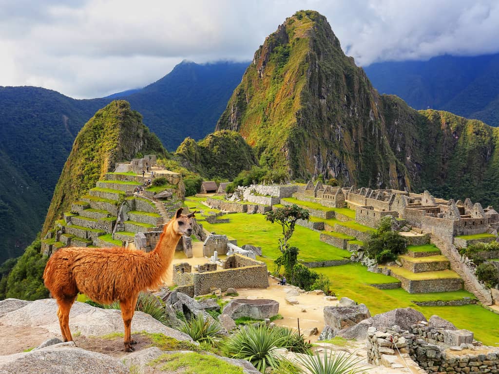
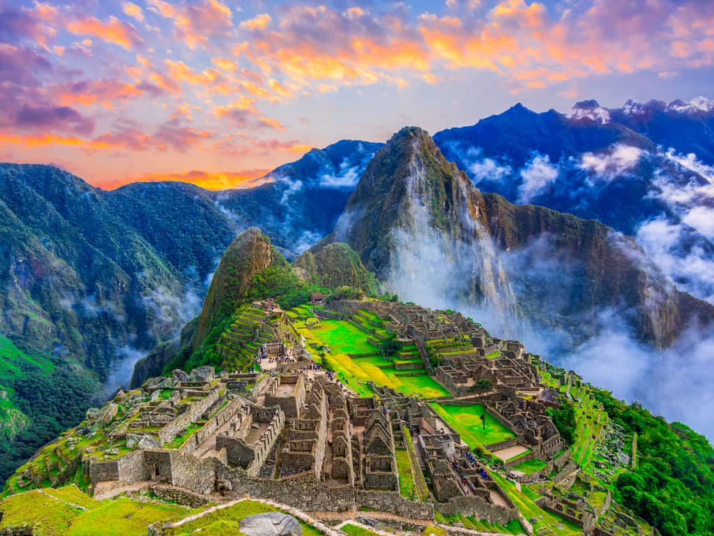
The stone city of Machu Picchu is by far a fascinating archaeological site in Peru. It is a testament of power and ingenuity of the Inca people, one of South America’s largest ancient empires.
Built around the mid-fifteenth century, Machu Picchu is one of the few well-preserved remnants of the Inca civilization.
What is Machu Picchu, and who built them?
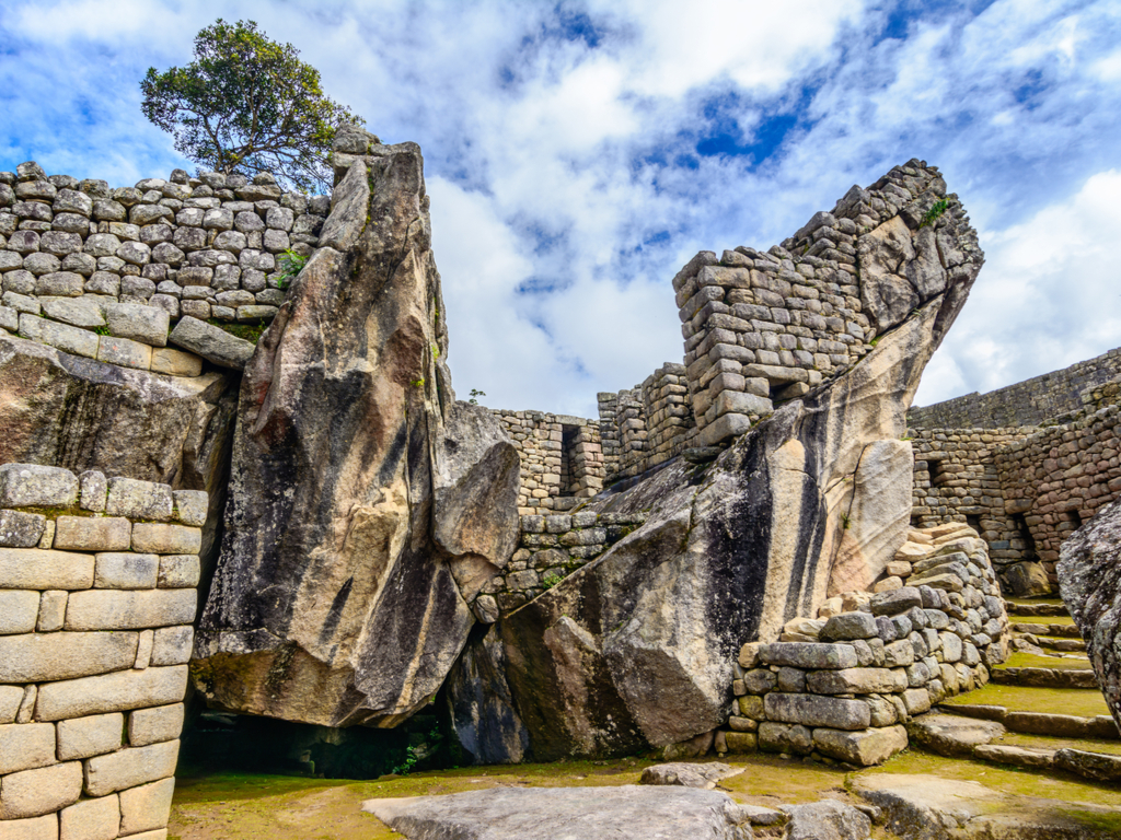
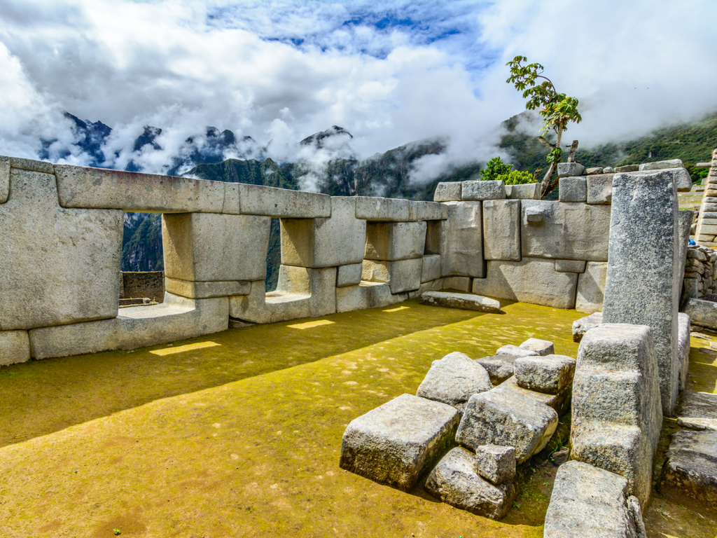
Machu Picchu is a striking example of the Inca’s engineering feat. The Inca people constructed Machu Picchu’s palaces, terraces, temples, plazas, and the infrastructure using only stones.
Mind you, they didn’t use any metal tools, wheels, or mortar while building these structures.
Nonetheless, the stones of Machu Picchu buildings are so sharply and precisely cut that they snuggly fit into one another, even after forgoing the use of mortar. You just can’t separate two rocks.
Explore the majestic ruins of Machu Picchu, a testament to Incan ingenuity, set high in the Peruvian Andes.
Another thing to note is that the location of Machu Picchu is between two fault plates. This factor makes it prone to damage due to earthquakes. The stones’ unique cut and fit, make sure that they bounce back to their original position after shaking. These engineering marvels have managed to preserve Machu Picchu for over 500 years.
Why it was built, you may ask. Its purpose is still a mystery to many archaeologists. These human-made structures seem to align perfectly with certain astrological events. However, all of a sudden, in the sixteenth century, Machu Picchu was abandoned.
Marvel at the harmony of ancient Incan architecture with the natural landscape, with Huayna Picchu towering over Machu Picchu.
Who discovered Machu Picchu?
Archaeologists couldn’t configure the purpose of the site since the Incas had no written language. It was long isolated and unnoticed until Hiram Bingham, an American archaeologist, discovered it in 1911.
How to get to Machu Picchu?
Below are our recommendations for routes from Lima to Machu Picchu. First, get to Cusco from Lima by plane or the Peru Hop bus. Then you may choose any of the following :
If you have a tight schedule, you can go by train: Get on a train from Cusco, followed by a bus ride to the entrance of the ruins.
But if you want to enjoy your travel to the fullest, keep four days in hand and follow the classic Inca trail. Trek all the way, and explore some picturesque spots on your ways such as Phuyupatamarca and WinyaWayna.
Admire the intricate stone walls of Machu Picchu, a testament to the Incas’ advanced masonry skills.
How much does it cost to get there?
The entry ticket costs somewhere around $60-80. If you travel with minimal expenditure, by trekking and bus and stay in the cheapest of hotels, you are bound to spend $250 on the entire trip. At the same time, the average expense of a Machu Picchu trip, including flights to food, may go up to around $550.
What is the best time to visit Machu Picchu?
We recommend booking your Machu Picchu tours for October, as the weather is pleasant and you get to face the little crowd.
Witness the breathtaking views from the Sun Gate, the historic entrance to the wonders of Machu Picchu.
Where to stay when visiting this ancient Inca place?
In 1983, Machu Picchu got the title of the UNESCO World Heritage site, and since then, it has attracted millions of tourists each year. Located more than 7,000 feet above the sea level on the mighty Andes Mountains, this marvelous symbol of the Incan empire was designated as one of the Seven Wonders of the World in 2007.
Burano is an astounding city of colorful houses and handmade laces in the northern Venetian Lagoon of Italy. With so much to explore and capture, let us take to the city of colors and its details through this article. Keep reading ahead to know more about Burano and it’s beauty. We have included a proper information guide in this article for your convenience.
The bright colored houses, the amazingly soothing lagoon, and the beautiful lace around the city make this place the paradise of colors in Italy. With happiness spread everywhere and some mouth-watering casual eateries, the city is awe-interesting.
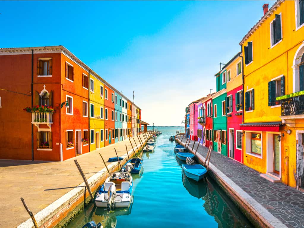
The picturesque island of Burano in the northern Venetian Lagoon is famous for its brightly colored houses and handmade lace. The beautiful lagoon flowing through the city, the vividly colorful houses along the bay, and the crystal clear sky above the head, makes Burano Italy just color-perfect.
How do I get from Venice to Burano Island?
With the road distance of approximately 63 Kilometers, Venice to Burano is a stunning trip. The beauty of Italy and the romantic climate makes it interesting. The Vaporetto line that runs between Venice to Burano on the number 12 is the best option.
Experience the picturesque setting of Burano’s canals, lined with boats and colorful houses, echoing the island’s fishing history.
The mesmerizing ferry trip from Venice’s San Zaccaria to Burano and Murano is just classy. With just travel of 45 minutes, the stunning Burano island is ready to welcome you.
What is the island of Burano famous for?
Burano Island in the Venetian Lagoon of Italy is a perfect holiday destination. With the beautiful colorful houses and the unique handmade laces, this island is astonishingly superb.
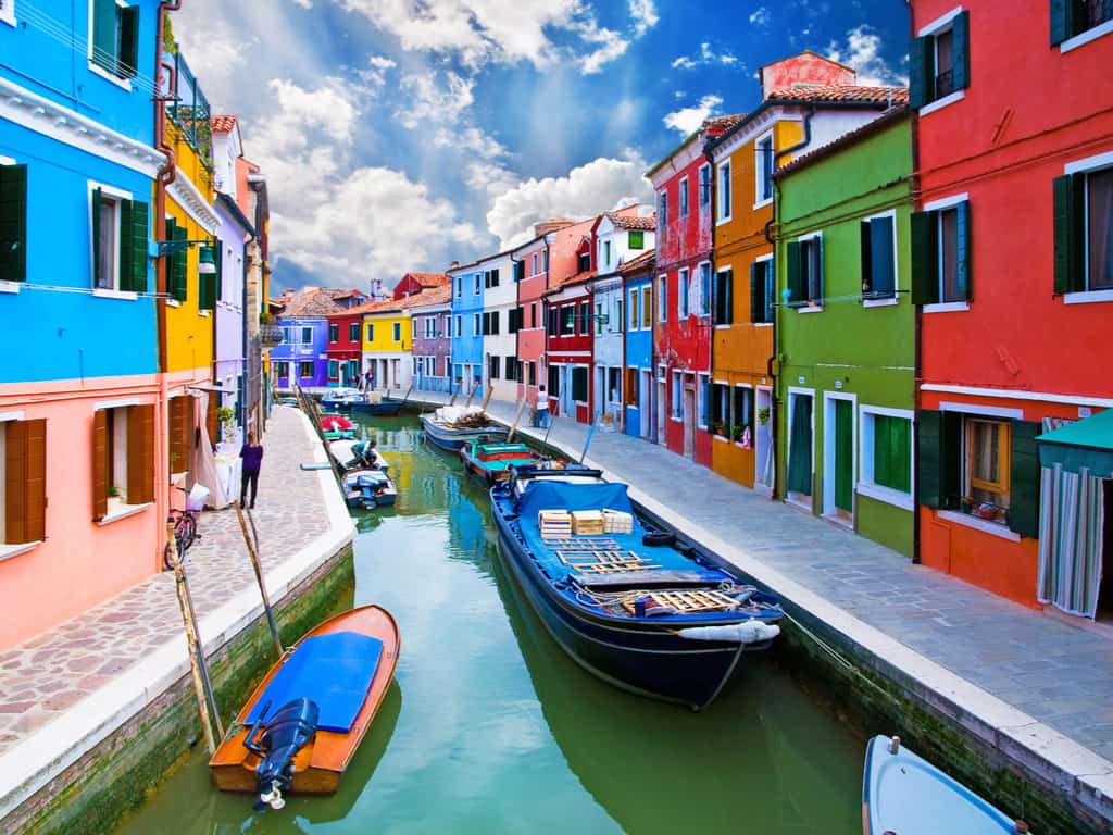
The city is at its best from the early in the morning during the sunrise, to late in the evening during the sunset or midnight. With the calmness of the city, cooling and soothing lakes, and vivid colors spread, Burano is the most colorful and famous city of Italy.
Discover the vibrant colors of Burano, Italy, where each house along the canal paints a picture of this island’s unique charm.
Why is this Italian city so colorful?
With the legend and stories spread about Burano Italy, the tale of the stunning colorful houses is also linked. The city of fishermen is painted with vivid and bright hue shades to help the fishermen reach their homes in the dark and thick fog of lagoon.
The bright walls reflecting the light and their un-shattered image reflected in the clear water of the lagoon, create a paradise at this beautiful city of Burano.
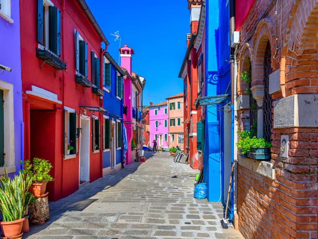
Stroll through the narrow streets of Burano, a journey filled with vibrant colors and enchanting architectural surprises.
What to do at Burano?
The alluring beauty of the colorful houses, the calm breeze, turquoise blue water, clear sky, and the beauty spread everywhere, Burano Island offers a lot to explore and expedite.
The best things to do here are:
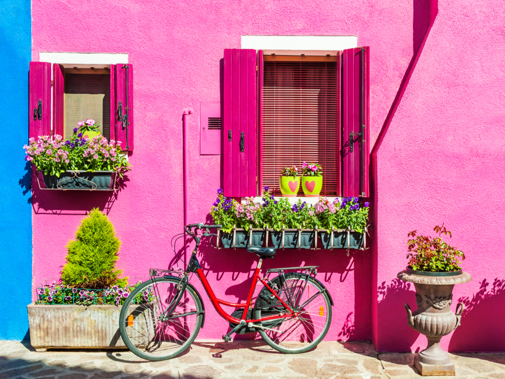
Visit the colorful homes
Offer your prayer at St. Martin’s Church
Adore the handmade laces
Stroll the streets and have a look at the spectacular fisherman boats
Stroll around the Piazza Galuppi, the unique square of Burano
Spend some time at lace museum
Get drowned in the beauty of the city and the Murano Glass
Meet the local artisans of Burano as they create traditional lace, a craft deeply woven into the island’s cultural fabric.
When should one visit Burano?
With the hues of color and the crystal clear blue water, and soothing climate, the city of Burano Italy is perfect to visit all round the year. With the average temperature and humidity, the ideal time to visit the city of colorful houses is from April to October.
The astounding and sparkling colorful houses, the calm lagoon, the soothing climate, and a calm breeze flowing throughout the city, Burano Italy is breathtaking. With the phenomenal site-seeing, beautiful sunrise, and sunset, every moment is mystical and magical.
Traveling to Burano, dreamy land of colorful houses is sure to take place in your bucket-list!
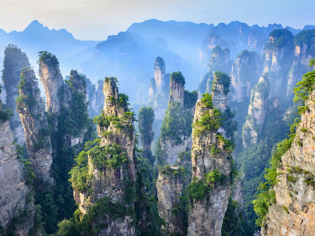
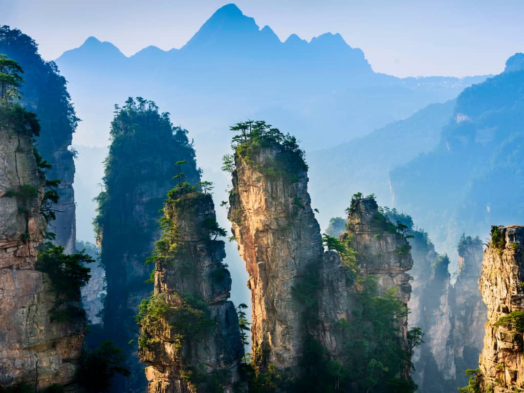
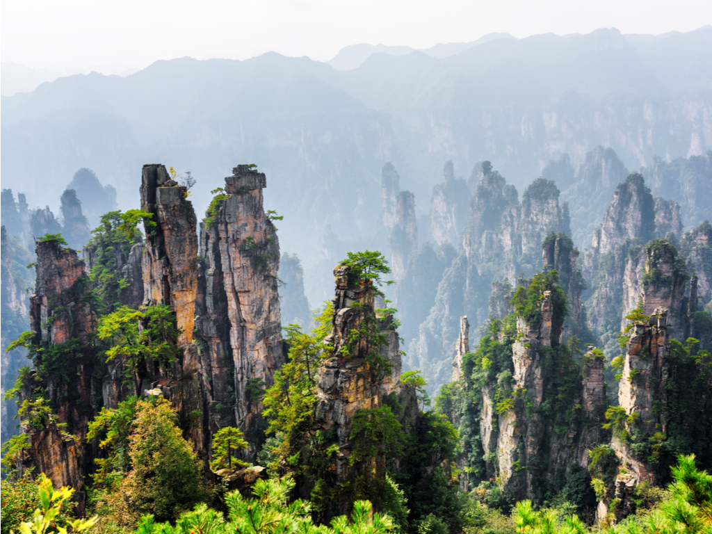
The Tianzi Mountains in China’s Zhangjiajie National Forest Park and the surrounding Wulingyuan Scenic Area offer visitors a chance to experience some of the most stunning natural landscapes and cultural heritage in China. Whether you’re exploring the Avatar Mountains, hiking through the park’s lush forests, or taking in the breathtaking views from the glass bridge or cable cars, there is something for everyone in this incredible destination. With a little planning and preparation, you can make the most of your visit to Zhangjiajie National Forest Park and create memories that will last a lifetime.
If you’re fascinated by the natural scenery of the Avatar movie and also want to physically experience it, then you need to visit the Zhangjiajie mountains in China.
In this article, we will take you on a journey through the top things to see and do at Tianzi Mountains in China’s Zhangjiajie National Forest Park.
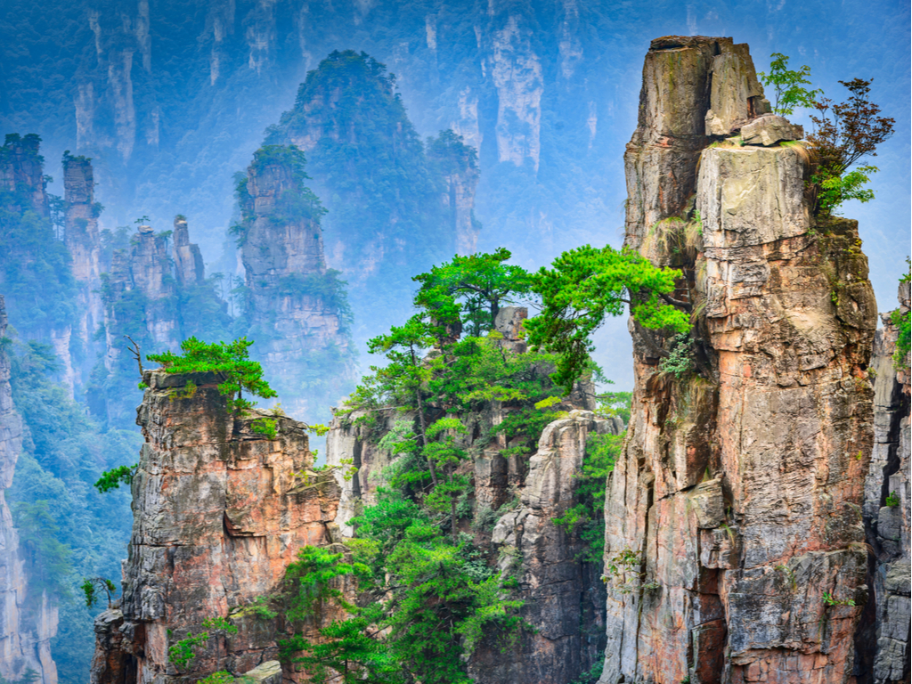
Explore the stunning Tianzi Mountains in Zhangjiajie’s Wulingyuan Scenic Area, known for their towering sandstone pillars and lush forests.
Exploring the Avatar Mountains: A Guide to Tianzi Mountains’ Iconic Peaks
The Tianzi Mountains are famous for their iconic peaks, which inspired the floating Hallelujah Mountains in the blockbuster movie Avatar. The most famous of these peaks is the pillar-like formation called the Southern Sky Column, which stands 1,080 meters tall. To get a bird’s-eye view of the Avatar Mountains, take a cable car up to the summit of Tianzi Mountain. From there, you can see panoramic views of the park’s peaks and valleys.
Another must-see peak is the Yuanjiajie Scenic Area, which is home to the Bailong Elevator, the world’s tallest outdoor elevator. The elevator takes visitors up 326 meters to a viewing platform at the top of a sheer cliff face. From there, you can take in stunning views of the surrounding peaks and forests.
Tips for Hiking in Zhangjiajie: What to Know Before You Go
Zhangjiajie National Forest Park is a hiker’s paradise, with trails that wind through some of the most stunning landscapes in the world. However, hiking in the park can be challenging, especially for those who are not used to steep inclines and rugged terrain. Here are some tips for hiking in Zhangjiajie:
Wear comfortable, sturdy shoes with good traction.
Dress in layers, as the weather can change quickly in the mountains.
Bring plenty of water and snacks, as there are limited places to buy food and drinks in the park.
Carry a map and a compass, as some of the trails can be confusing and poorly marked.
Be prepared for steep inclines and narrow paths, especially in the more remote areas of the park.
A Guide to Tianzi Mountains Glass Bridge: The World’s Longest and Highest Glass-Bottomed Bridge
The Zhangjiajie Glass Bridge is a marvel of modern engineering, stretching 430 meters across a deep canyon and standing 300 meters above the ground. It is the world’s longest and highest glass-bottomed bridge, and offers visitors a heart-pumping experience unlike any other. Walking across the bridge can be terrifying, as the glass panels beneath your feet allow you to see all the way down to the canyon floor.
To avoid long lines and crowds, it is recommended that you book your visit in advance. Visitors are only allowed to cross the bridge in groups of 10, and tickets are limited. It is also important to note that the bridge can be closed in inclement weather, so be sure to check the forecast before you go.
Witness the mystical beauty of a misty morning in the Tianzi Mountains, part of the enchanting Wulingyuan Scenic Area in Zhangjiajie.
Discovering the Beauty of Tianmen Mountain: A Day Trip from Zhangjiajie
Just a short distance from Zhangjiajie National Forest Park is Tianmen Mountain, another natural wonder that is not to be missed. The mountain is home to the Tianmen Cave, a natural arch that is 131 meters tall and 57 meters wide. To reach the cave, visitors must take a cable car up the mountain and climb 999 steps.
The mountain is also home to a glass walkway that extends out over the edge of a cliff, as well as a stunning waterfall and a temple that is built into the side of a cliff. There are plenty of hiking trails and scenic spots to explore, making Tianmen Mountain a great day trip from Zhangjiajie.
How to Avoid the Crowds in Zhangjiajie
Zhangjiajie National Forest Park is one of China’s top tourist destinations, so it can get quite crowded, especially during peak travel seasons. However, there are some off-the-beaten-path destinations within the park that are worth exploring, and can help you avoid the crowds. Here are a few options:
Golden Whip Stream: This scenic area is located in the center of the park, and features crystal-clear waters, towering cliffs, and lush vegetation. The trail along the stream is a pleasant, leisurely walk that is suitable for all fitness levels. While it can still get busy, it is generally less crowded than some of the park’s more famous attractions.
Huangshi Village: This area is located in the western part of the park, and offers stunning views of the surrounding peaks and valleys. The trail can be quite steep and strenuous in places, but the payoff is worth it. The area can get crowded during peak season, but it is generally less busy than the Avatar Mountains or the Glass Bridge.
Baofeng Lake: This scenic lake is located in the southern part of the park, and can be reached by a short boat ride. The lake is surrounded by towering cliffs and dense forests, and is a peaceful, relaxing oasis in the midst of the park’s hustle and bustle.
Exploring Zhangjiajie’s Unique Flora and Fauna
Zhangjiajie National Forest Park is home to a rich array of flora and fauna, much of which is unique to the area. Some of the park’s most interesting plants include the Chinese yew, which is a slow-growing, long-lived tree that is used in traditional Chinese medicine, and the Chinese dove tree, which is known for its distinctive, fragrant flowers.
The park is also home to a wide range of animals, including macaques, civets, and many species of birds. The park’s most famous resident, however, is the rare and endangered South China tiger. While it is highly unlikely that you will see one of these elusive creatures during your visit, the park is working hard to protect and preserve the species.
Admiring the Stunning Landscapes of the Wulingyuan Scenic Area
Zhangjiajie National Forest Park is just one part of the larger Wulingyuan Scenic Area, which covers more than 26,000 hectares of stunning natural landscapes. In addition to the Avatar Mountains and other famous peaks, the area is home to dense forests, deep canyons, and rushing rivers.
One of the most popular ways to explore the Wulingyuan Scenic Area is by taking a leisurely boat ride down the Baofeng Lake. The lake is surrounded by towering cliffs and dense forests, and the boat ride is a peaceful, scenic way to take in the area’s beauty.
Sunset illuminating the peaks of Tianzi Mountains, casting a golden glow over Zhangjiajie’s Wulingyuan Scenic Area.
Zhangjiajie’s Cable Cars: Which One to Take and What to Expect
Zhangjiajie National Forest Park is home to a number of cable cars that can take visitors up to some of the park’s most stunning peaks and viewpoints. The cable cars are a convenient and efficient way to get around the park, but they can also be quite crowded during peak season. Here’s a rundown of some of the park’s cable cars:
Bailong Elevator: This is the world’s tallest outdoor elevator, and takes visitors up to the top of the Yuanjiajie Scenic Area. It can be quite crowded, but the views from the top are worth it.
Tianzi Mountain Cable Car: This cable car takes visitors up to the top of Tianzi Mountain, where you can see panoramic views of the Avatar Mountains and surrounding areas.
Huangshizhai Cable Car: This cable car takes visitors up to the Huangshizhai ScenicArea, which is located in the western part of the park. From the top, you can see sweeping views of the surrounding valleys and peaks.
Jinbian Cable Car: This cable car takes visitors up to the Jinbian Stream, which is a popular area for hiking and exploring. The cable car ride offers stunning views of the park’s rugged landscapes.
While the cable cars can be a bit pricey, they are generally a worthwhile investment, as they can save you time and energy in getting to some of the park’s more remote areas.
What is Zhangjiajie famous for?
Zhangjiajie is popular for its 3,000 rock pillars. These pillars are over 1,000 feet tall and densely covered with green foliage. They were formed naturally by erosion and now they bring in at least 30 million tourists each year.
Among these pillars, one was known as the “Southern Sky Column” and its height crossed 3,544 feet in the air, which is equal to 78 school buses in length.
In 2010 it was renamed “Avatar Hallelujah Mountain” – after the movie “Avatar”. The movie used pictures of the pinnacles and took inspiration for the floating mountain of Pandora.
The Cultural Significance of Zhangjiajie and Its Place in Chinese History
The Tianzi Mountains in China’s Zhangjiajie National Forest Park and the surrounding Wulingyuan Scenic Area have played an important role in Chinese history and culture for centuries. The area is home to several minority groups, including the Tujia, Miao, and Bai people, who have their own unique languages, traditions, and customs.
One of the most important cultural sites in the area is the Huangshi Village, which was once a strategic military outpost during the Ming Dynasty. The village is now a popular tourist destination, and offers stunning views of the surrounding peaks and valleys.
Another cultural highlight is the Zhangjiajie Grand Canyon Glass Bridge, which is designed to look like a traditional Chinese ink painting. The bridge is not only an engineering marvel, but also a nod to China’s rich artistic and cultural heritage.
In addition to its cultural significance, Zhangjiajie National Forest Park is also an important site for scientific research and preservation. The park is home to more than 3,000 plant species, as well as a wide range of animals, many of which are rare and endangered.
Discover the Tianzi Mountains from above, with an aerial view showcasing the lush valleys and sandstone formations in Wulingyuan.
How to get to Zhangjiajie in China
Zhangjiajie can be accessed by either air or railroad. Other major tourist cities in China nearby are Guilin, Chengdu, Shanghai, and Beijing. However, the most convenient way to get to Zhangjiajie is by air.
Once you get to Zhangjiajie, there are several local means of transportation. Recommended are the buses from the city to the Wulingyuan Scenic Area and Zhangjiajie National Forest Park China.
Accessing Zhangjiajie by air
Zhangjiajie Hehua International Airport is located in Yongding District in Zhangjiajie. From there you will get direct flights to and Shenzhen, Guangzhou, Shanghai, Beijing, Changsha, and other important Chinese cities.
In case you are in any other Chinese city that doesn’t offer a direct flight to Zhangjiajie, you can take a connecting flight at Changsha, Guangzhou, or Shanghai.
Note that most flights to Zhangjiajie land in the evening. You can easily get city buses, airport shuttle buses, and taxis from the airport to various areas in Zhangjiajie city.
Accessing Zhangjiajie by railroad
Zhangjiajie Railway Station offers a well-structured rail network that directly links Zhangjiajie to most cities in China like Changsha, Guiyang, Shenzhen, Guangzhou, Shanghai, and Beijing.
The rail station is located 2km south of the center of the city and 1km away from the Tianmen Mountain cableway station.
One reason why getting to Zhangjiajie by railroad is not advisable is because the journey usually takes long hours. Nevertheless, if you’re traveling to Zhangjiajie from Guilin or Yichang, going by train can be the better option.
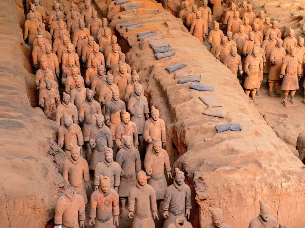
No chapter in the annals of history is as intriguing as the story of how a few peasants stumbled upon this historical monument in Shaanxi, China. The archeological value of the Terracotta Army is only compounded by the extremely individualized figurines. Do you still have to wonder why this UNESCO World Heritage site is on our radar?
The ancient sculptors demonstrated extreme attention and meticulousness while moulding these figures.
Why was the Terracotta Army built?
Only one thing comes to mind when you think of a series of Chinese warrior statues, right? However, the inspiration behind the Terracotta Army was not to promote warmongering but to celebrate the immensely complex administrational structure in China during Qin Shi Huangdi’s illustrious reign. As a tribute to the innovations of a standardized writing script, measures, and weights discovered during the emperor’s rule, the mausoleum intended to incorporate the Chinese statues as well.
Not only do you find warriors here but also waterfowl, musicians, court officials, and acrobat troupes. The Terracotta Army symbolizes the microcosm of the court that existed at that time in history – his death marked the demise of one of the most Byzantine political systems that the world has ever witnessed.
Explore the awe-inspiring Terracotta Army in Xi’an, a magnificent testament to China’s ancient history.
Who built the Terracotta Army
Shih Chi – an ancient Chinese scripture – is the ultimate source for resources on the Terracotta Army. It points out that Qin Shi Huangdi, the ‘First Emperor’ of the Qin state, ordered his best artisans to construct a mausoleum in his honor.
Zhang Han, the Senior General, and Li Si, the Prime Minister of Qin, was assigned the task of overseeing the design and layout aspects of this modern marvel. The intricately designed Chinese statues formed an essential part of the mausoleum’s imperial structure.
Discover the intricate details of each Terracotta soldier, a masterpiece of ancient Chinese art and craftsmanship.
When was the Terracotta Army constructed?
The history of the Terracotta Army is one that dates back to 2200 years between the period 247 BC to 208 BC.
What is the best time to visit and see the Chinese statues?
The Chinese warriors are available to tourists throughout the year. But if you want to pick a time of the year, we would recommend visiting the museum between September and October or from March to May. This is because the weather is pleasant during these times and will afford a leisurely trip to this magnificent indoor museum.
Bonus: If you wish to avoid crowds, you might want to visit during the lunch hour.
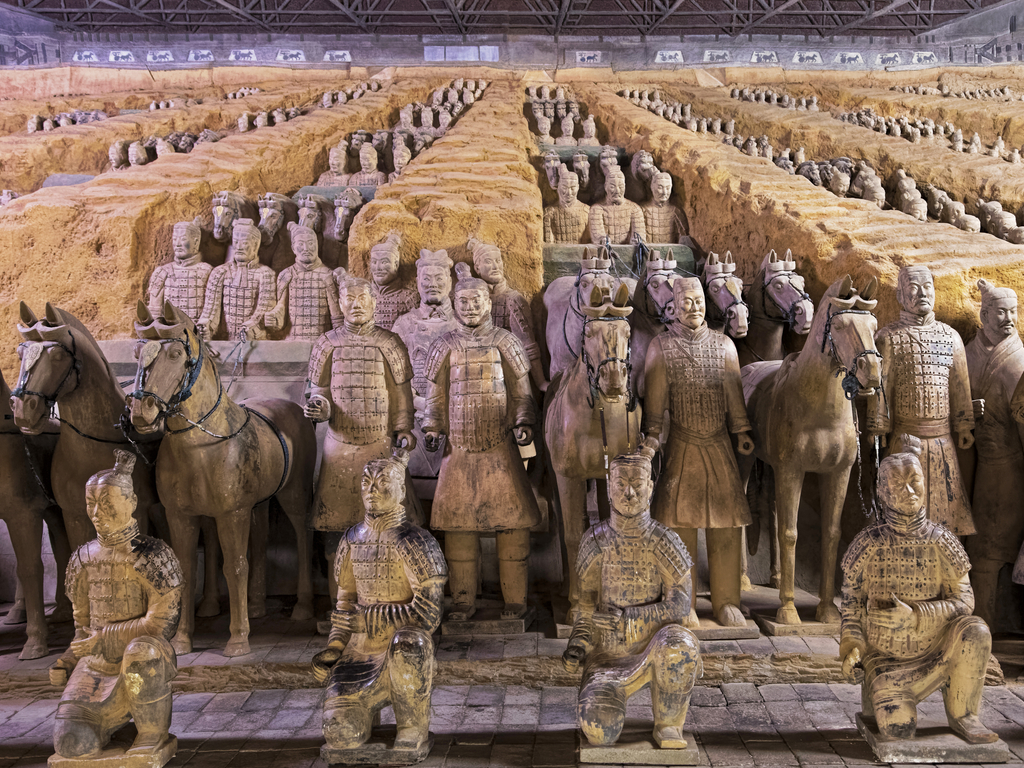
Witness the grand scale of the Terracotta Army burial site, where hundreds of statues stand guard in ancient China.
Top 3 interesting facts about Terracotta Army
The Chinese statues measure about 1.85 meters in height on an average basis. This is because of ancient war forms required strong, tall soldiers.
The Terracotta Army is grey now due to humidity. Originally, they were originally quite colorful with armor and faces painted with bright green, red, and even purple colors.
The Chinese warriors are only found in three of the four pits that are located at the mausoleum.
Admire the uniqueness of each Terracotta soldier, with distinct facial expressions reflecting the diversity of ancient China’s army.
Where to stay during the visit of the eternal Chinese heroes?
Trust us – you will definitely depart the Terracotta Army with a sense of awe and wonder for the magnificence of human history.
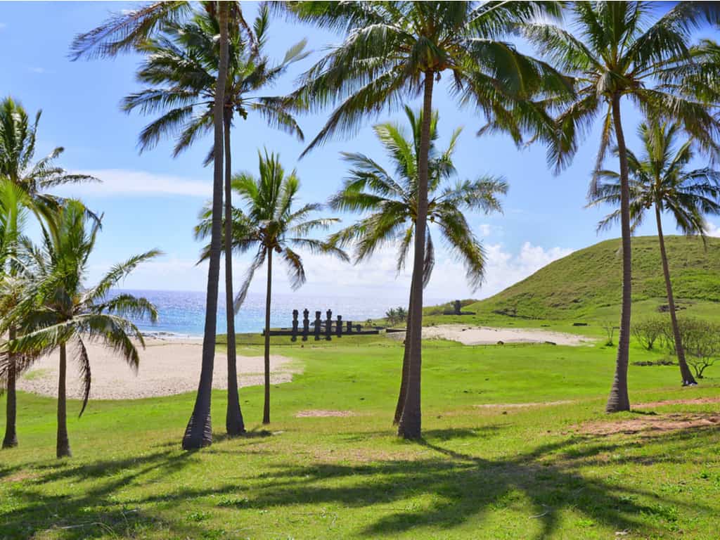
Searching for a unique travel destination for your next trip? Your search ends here. Rapa Nui National Park & Easter Island are located in the Pacific Ocean, approximately two thousand miles away from South America. Rapa Nui National Park comprises approximately 42 percent of Easter Island.
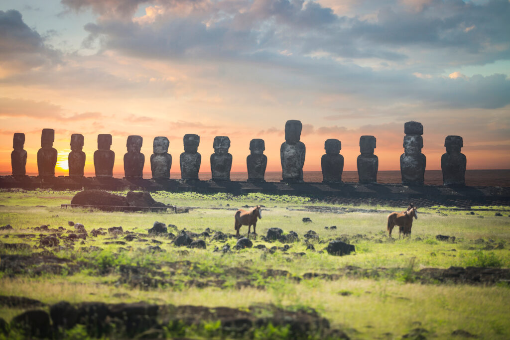
This destination is a part of the Polynesian triangle along with New Zealand and Hawaii. The 900 monumental sculptures of Easter Island have made this a major travel destination.
How to get to Easter Island?
Tourists dedicate two days to travel to Easter Island. You will have to travel to Santiago, the Chilean capital, first. LAN Airlines offer six-hour one flight from Santiago to Easter Island on a regular basis. The approximate travel time is around one and a half days.
How much does it cost to go to Easter Island?
You can gain access to Rapa Nui National Park by buying a ticket worth 80 dollars at the National Park booth at Mataveri Airport. Alternatively, tickets are also available at Ma’u Henua Indigenous Community Central Office in Hanga Roa.
The ticket facilitates you with an entry in Rano Kau Quarry and Ahu Tongariki. We promise that the experience is worth it and justifies the slightly higher entrance fee.
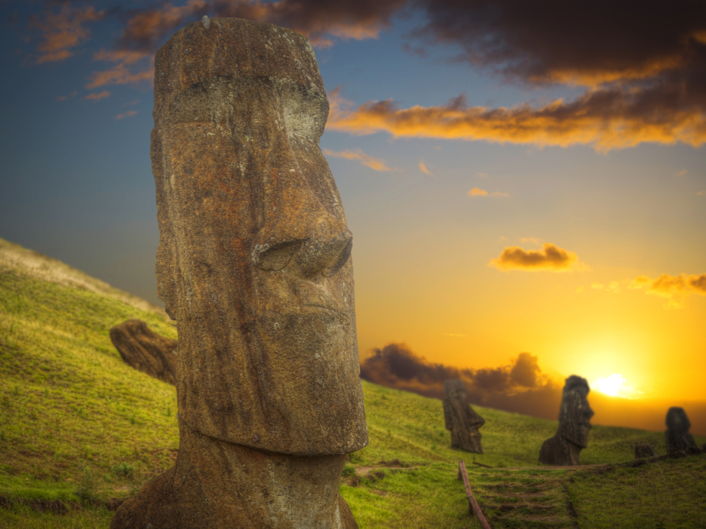
Witness the captivating sunset at Ahu Tongariki, where the moai statues of Easter Island are bathed in golden light.
Why is Easter Island called Easter Island?
It’s time for a history lesson. Contrary to popular opinion, Jacob Roggeveen – a Dutch explorer – discovered this eponymous island while sailing south Pacific on April 5, 1722.
This date coincided with the Easter holiday, according to the Christian calendar. Feeling inspired, Jacob named this island ‘Paasch-Eyland’, which stands for ‘Easter Island’ in Dutch. Isn’t this Easter Island fact mesmerizing?
The Top 3 Easter Island Facts
Easter Island was the first Pacific island nation to be classified as a UNESCO World Heritage Site.
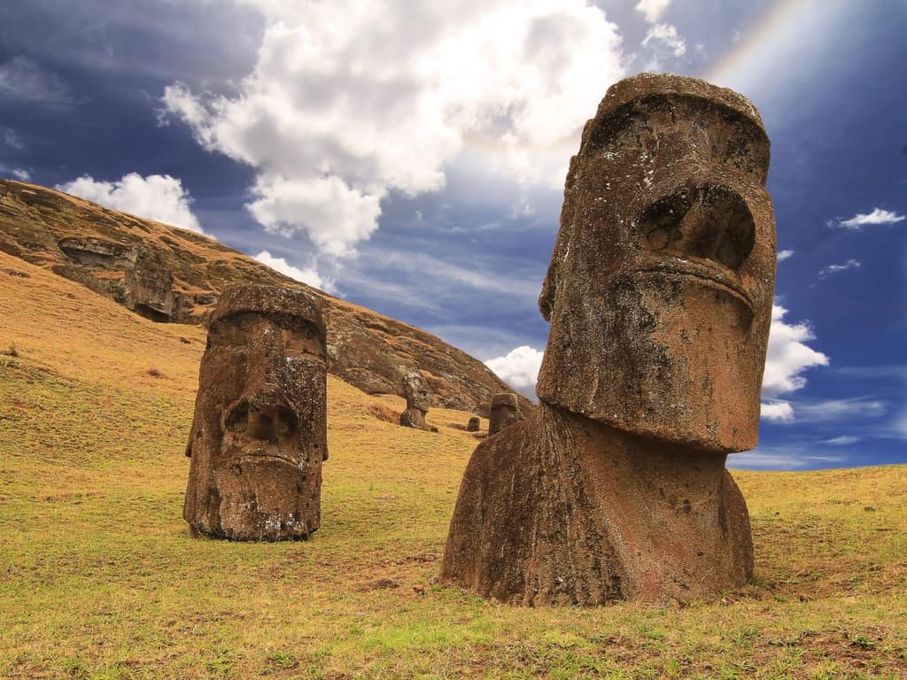
None of the monumental sculptures of Easter Island were erect when they were first discovered. The ones you see today have been re-erected.
The statues are believed to harbor spirits of tribal ancestors. They are perceived as the symbol of good fortune by locals.
Relax on the pristine Anakena Beach of Easter Island, a perfect blend of historical intrigue and tropical beauty.
What is the best time to visit Rapa Nui National Park & Easter Island?
The best possible time of the year when you should visit Rapa Nui National Park & Easter Island is between October and December and April and June. The temperate climate makes sightseeing easy and the prices are quite reasonable.
If you wish to attend the Tapati Rapa Nui Festival, you will have to visit during February. The cool ocean breeze effortlessly complements the tropical weather, thereby making tourism comfortable.
However, the temperatures can sometimes exceed 27 degrees Celsius, so make sure that you carry ample water and apply sunscreen.
Explore the enigmatic moai statues of Easter Island, a testament to the island’s rich and mysterious history.
Where should you stay in Rapa Nui National Park & Easter Island?
Hare Nua Hotel Boutique: Provides the coziest rooms filled with greens and antique straw furniture, with a traditional wooden bathtub to calm your nerves at the end of your adventures.
Hotel Maea Hare Repa: The choice for minimalistic and comfortable accommodation and delicious breakfast buffet.
Pikera Uri Eco Lodge: Classy and vintage with a mesmerizing ocean view, it never fails to please the visitors.
Inaki Uhi Hotel: One of our top picks, thanks to its convenient location along with its homely feel and highly co-operative and gentle staff.
Hotel Hangaroa Eco Village & Spa: Fantastic service and celebrity style treatment right on the seashore! Also, it is at a walkable distance from the Hanga Roa.
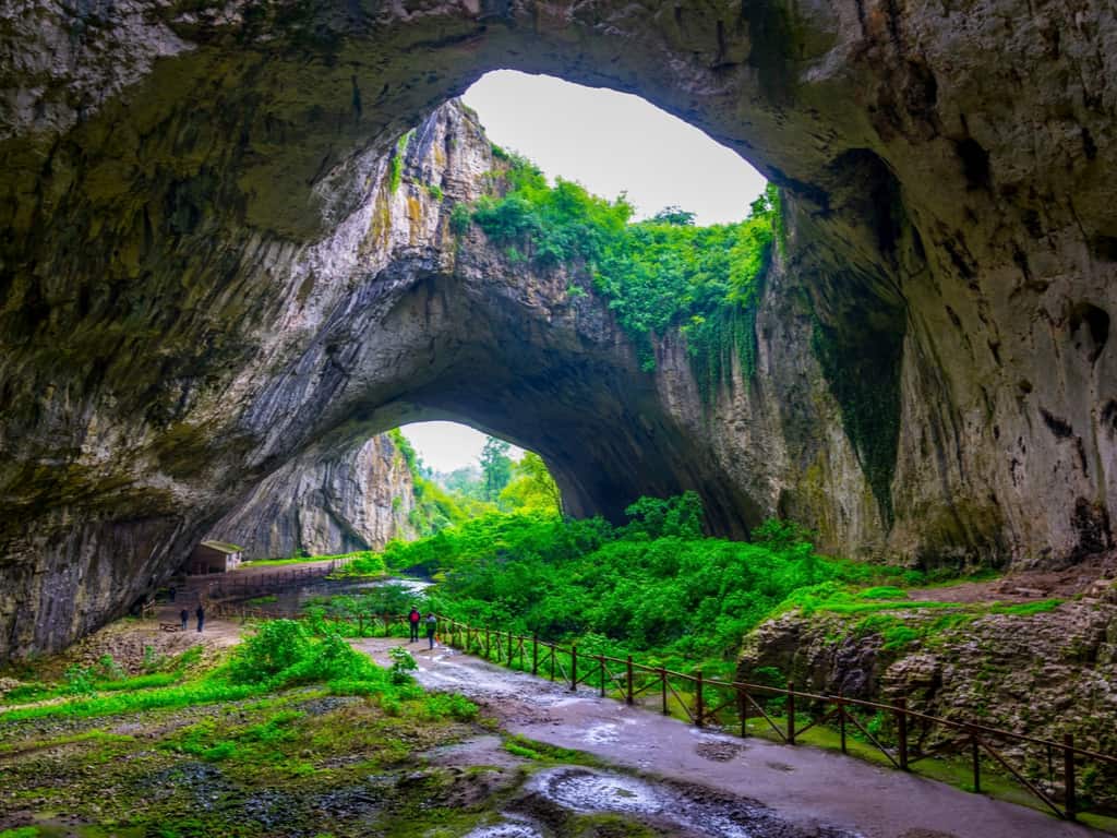
Devetashka Cave in Bulgaria comprises relics from Hollywood movies and the Cold War era. The story goes that it once was the residential spot for many tribes in the Neolithic and late Paleolithic period.
Located approximately 18 kilometers to the northeast section of Lovech, Devetashka Cave boasts of a ceiling that is 2442 meters high with a breadth of 60 meters.
This cave is regarded with high esteem by locals, who consider it a landmark of immense international potential, and by travelers who rightly believe it to be a cultural monument.
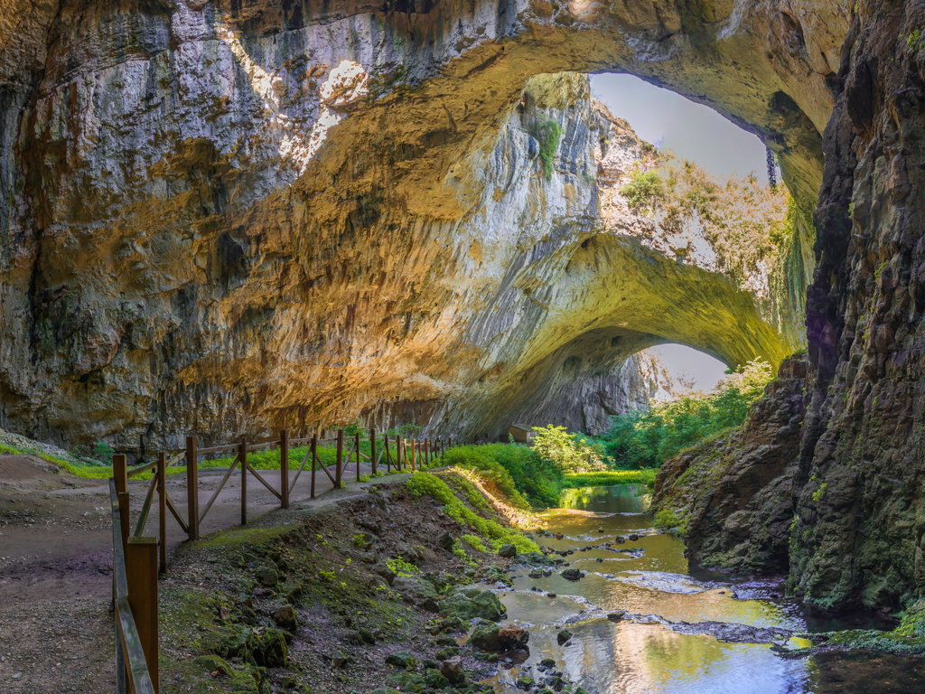
The Unique Beauty of Devetashka Cave in Bulgaria
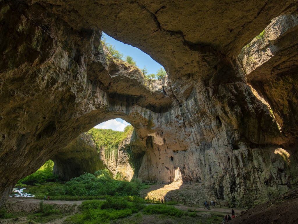
This cave is one of those places that make you feel as if you have entered a magical world. The surreal combination of greenery, large gaps in the cave’s ceiling, and a wide variety of bats and insects make it a unique tourist destination. Unlike other caves where you only find stillness, Devetashka is always brimming with the sound of swallows chirping and bats flapping their wings.
Marvel at the stunning views from inside Devetashka Cave, a dramatic play of light and shadow in Bulgaria.
There is an assortment of rock specimens available here, which include stalactites, stalagmites, and speleothems. The numerous naturally formed domes and rivulets only add to the charm of this ancient cave structure.
The entire cave is bathed in natural light that allows you to behold the natural beauty that surrounds you. You will want to keep visiting it again and again.
Witness the breathtaking natural skylights of Devetashka Cave, where sunlight dances through the caverns.
How to get to Devetashka Cave?
Reaching Devetashka is quite easy if you are approaching it from Devetaki village, which is just two kilometers away. You can hike to the cave by following the path beside the village river.
Those who wish to opt for a more relaxing journey might ride a car on Road 301. You will have to cover a short distance on a concrete bridge and a dirt road and you will soon reach Devetashka Cave.
What is the entrance fee for Devetashka Cave?
The entrance fee for the cave is quite reasonable considering its astounding beauty. to gain access to this beatific cave Students and adults are charged 2 and 3 leva – something between 1 and 2 USD.
Discover the mystical interior of Devetashka Cave, famed for its expansive caverns and natural skylights in Bulgaria
What can you do on Devetashka Cave?
Devetashka Cave offers diverse attractions to tourists, including waterfall sightseeing, information gathering about the bats that inhabit the cave, photography, and exploring the historical points of interest.
Nowhere you do see as much multi-faceted beauty as you do in Bulgaria. While the scenic landscapes, pristine coastlines, and mountains are astoundingly beautiful, Devetashka Cave stands a class apart.
What is the best time to visit Devetashka Cave?
The best time to visit this magic Cave is during autumn, as the weather is neither too cold nor too hot during this time. Moreover, seasonal changes can be witnessed quite clearly.
Explore the grand entrance of Devetashka Cave, a natural wonder and a gateway to Bulgaria’s subterranean beauty
Where to stay nearby of Devetashka Cave?
Some of the amazing accommodations that you can try out while visiting are:
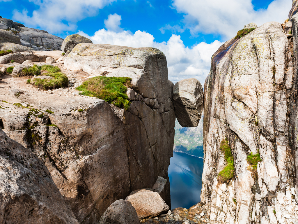
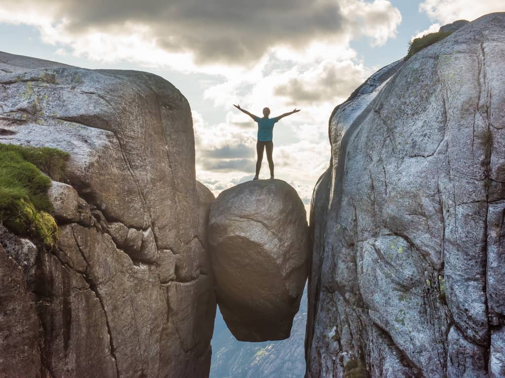
Kjeragbolten is a boulder that is wedged into a deep crevice in the Kjerag hill. It is suspended in the crevice and below it, is a 984-meter deep abyss. It was a result of recurrent reformations of the valleys in between the several ice ages.
The Kjeragbolten in Norway was formed in around 50,000 B.C. during the last glacial period.
Where is Kjeragbolten in Norway?
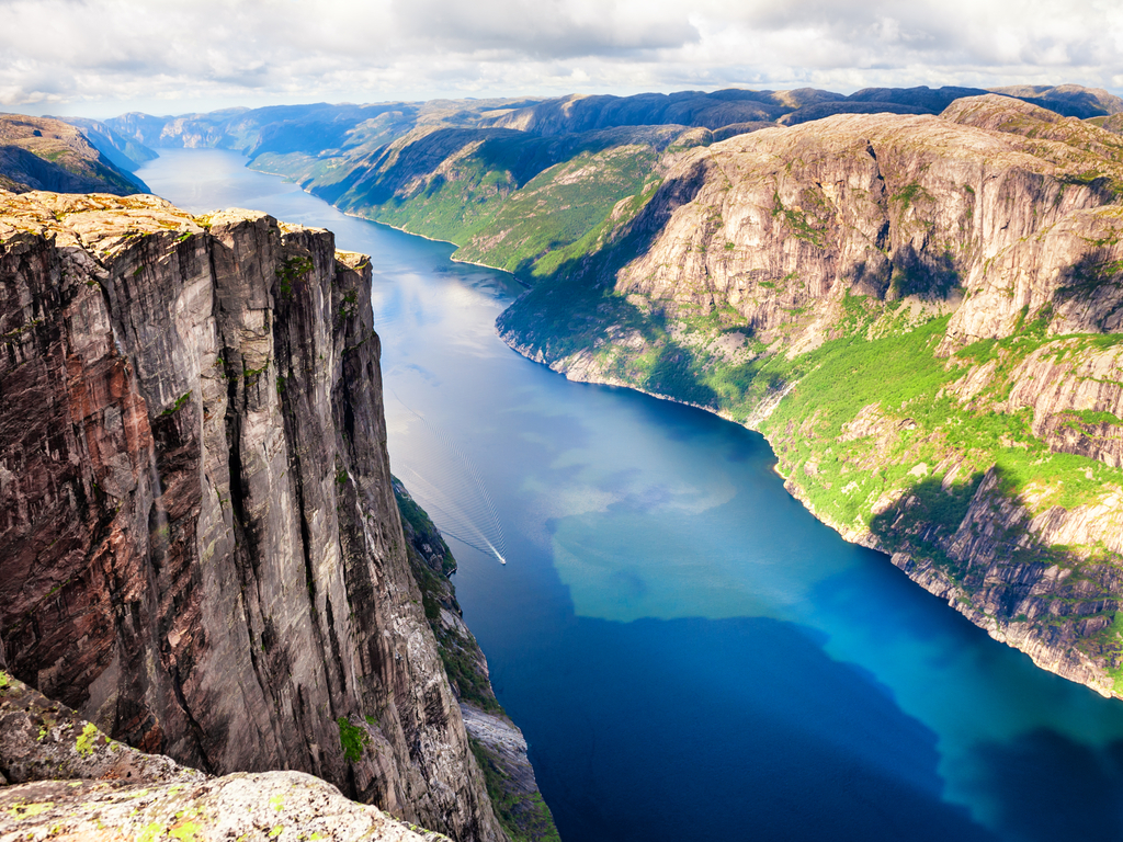
The Kjeragbolten sits on the Kjerag hill, which is located on the shore of Lysefjord. Lysefjord, in turn, is a fjord that you find towards the southwest of Lysebotn village. A fjord is a narrow extension of the sea in between the mountains and is a speciality of Norway.
Capture your own unforgettable moment on Kjeragbolten, with Norway’s breathtaking fjord as your backdrop.
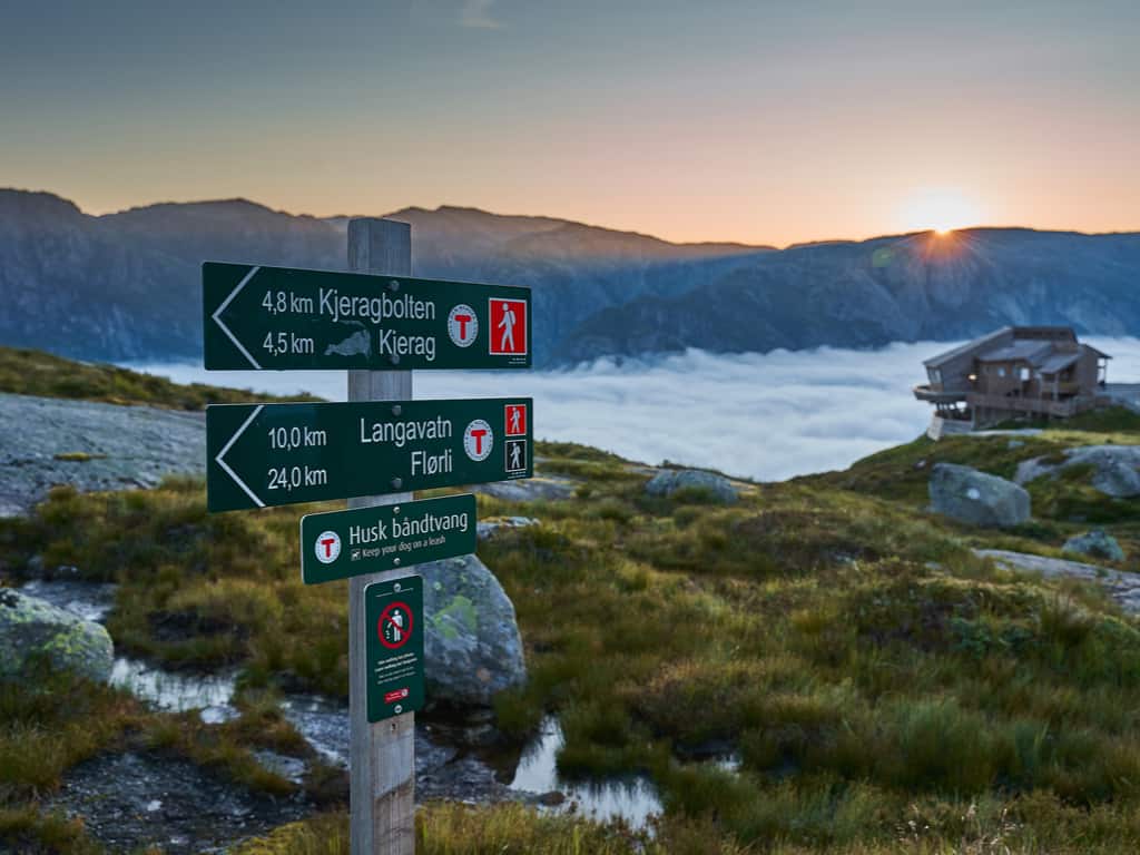
Let’s get you a route from Oslo to Kjeragbolten, since Oslo is the starting point of all Norway vacations.
From Oslo to Lysebotn: Lysebotn is the closest town to Kjeragbolten and is just 15 minutes away. You can fly from Oslo to Lysebotn or you may as well choose a car ride from Oslo to Lysebotn, which takes around 7 to 8 hours
From Lysebotn to Kjeragbolten trail: By car, it takes hardly 15 minutes to reach the bottom of the Kjeragbolten hike trail.
Marvel at the panoramic beauty of Lysefjord from Kjeragbolten, a stunning viewpoint in Norway’s rugged landscape.
Why do people climb Kjeragbolten, Norway?
Most people – if not all – visit the Kjeragbolten in Norway for the daring Kjeragbolten hike and for the breathtaking landscape views. You get to see from a thousand meters above and from the Kjerag plateau. The climax of the trip is almost always a photograph posed on top of Kjeragbolten.
What is the best time for the Kjeragbolten hike?
The summer season, of course. The Kjeragbolten hike follows a strict seasonal pattern to avoid fogs, rains, and harsh climate.
Embark on a hiking adventure to Kjeragbolten, a rewarding journey through Norway’s stunning natural terrain.
Is Kjeragbolten hike safe?
As challenging a climb Kjerag is, you find a couple of chains to assist you at the steepest parts. Furthermore, some red-colored T’s are painted on the rocks along the path, and thus you just can’t get lost or diverted. Fog and rain, if present, happens to be your worst enemies at the climb.
As of the infamous Kjeragbolten deaths, nobody has yet died from the Kjeragbolten hike itself. The few Kjeragbolten deaths were all due to base jumping from the boulder and not because of merely standing and falling from Kjeragbolten.
Experience the thrill of standing on Kjeragbolten, a unique rock suspended above a fjord in Norway, offering an adrenaline-pumping adventure.
How long does it take to hike Kjeragbolten?
The hike is bound to take a good 6 to 7 hours which includes both the uphill and downhill journey.
If you are a hiking daredevil, you surely can’t miss Kjeragbolten, Norway. Hike the Kjerag hill and enjoy the spectacular views of mountains and fjords and visualize the incredibly beautiful impact the ice ages have left on Norway.
Where to stay for the hike – Lysebotn, Norway?
The best possible way to spend nights is by camping out in the open, for an altogether magical experience. Make sure to bring a tent and other necessities if you prefer this option. However, in case you want to comfortably spend your nights indoors, check out on these:
Stavanger Bed and Breakfast:
Flørli 4444 Hostel: An affordable lodging that comes with dorms and also provides spectacular views of Lysefjord.
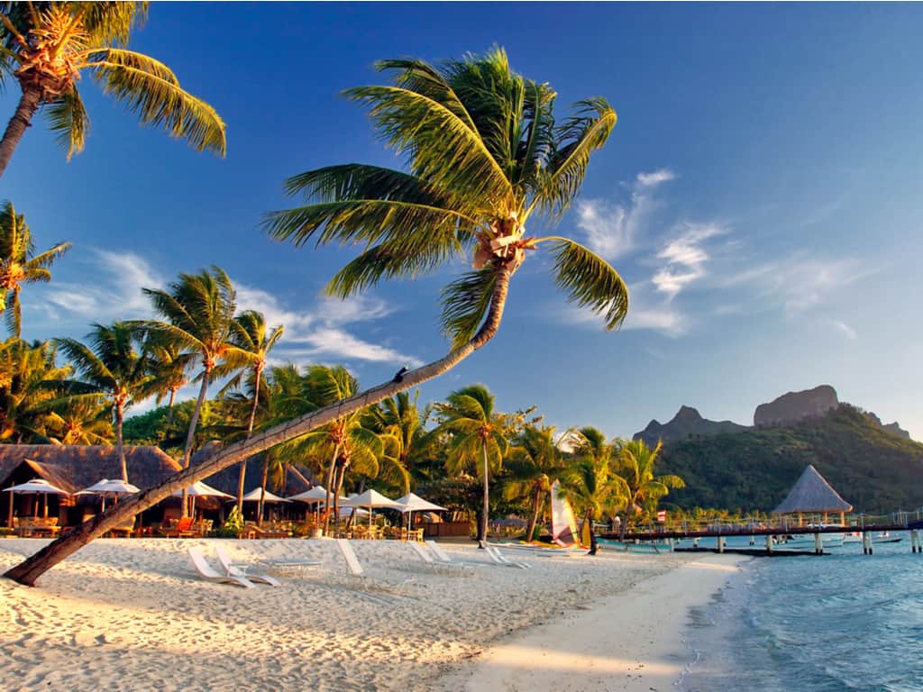
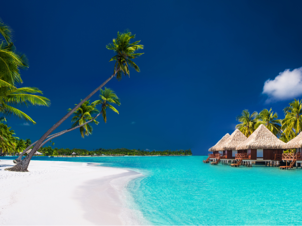
Bora Bora is a wild and beautiful island located in the heart of the South Pacific Ocean and is one of the world’s most relaxing destinations. Discover how this tiny little place is filled with life and treasures.
Go forth and explore this paradise, and we guarantee you won’t find enough words to describe this hidden place.
Where exactly is the island of Bora Bora located?
Bora Bora is one of the islands in the Society Islands of French Polynesia. It is situated at the central Pacific Ocean, 230 miles towards the northwest of Tahiti, and is surrounded by a barrier reef.
Experience the ultimate luxury in Bora Bora’s overwater bungalows, a serene escape amidst the azure waters.
How much does a trip to the Bora Bora Island cost?
The average cost, including international and inter-island flights to Bora Bora, food, accommodation, drinking, and recreational activities, rounds off to 7,000 – 9,000 USD considering a 7 day trip for a couple. It is hell expensive, thus.
How to get to Bora Bora Island?
Book your tickets really early if you don’t want to drill a hole in your pockets!
First fly to the Faa’s international Airport at Papeete, Tahiti.
From Tahiti, take another flight to Mote Mute, an islet of the Bora Bora main island.
From this Bora Bora main airport, take the ferry across the turquoise blue lagoon to the main island of Bora Bora.
Discover the stunning panoramic beauty of Bora Bora Island, a tropical paradise in French Polynesia.
Why to visit Bora Bora Island?
Step ashore and there you are, all welcomed by the natives with their sweet and happy island songs. From the breathtaking views of the mountain Otemaruto the crystal clear waters brimming with life – You can’t get just one reason to get here.
You get to enjoy your personal overwater or beachfront Resort. This place is an exotic honeymoon destination, and the relaxation it offers is unbelievably priceless.
Indulge in ultimate relaxation at a luxurious spa resort in Bora Bora, surrounded by breathtaking natural beauty.
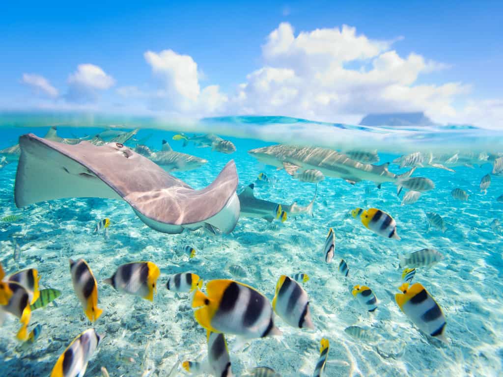
What to do in Bora Bora Island?
Spend a day exploring the lagoon and its vibrant marine life with a snorkel.
Savor the fresh beachy flavors of local dishes; we highly recommend checking out the famous Bloody Mary restaurant.
Relax at your bungalow.
Jump into the water and meet Bora Bora’s friendly stingrays and reef sharks.
Hire a bike and explore the island, and don’t forget to chill out at the local cafes.
Lounge the afternoon away at the Matira beach, the most popular beach of Bora Bora.
Take something luxury home: get your own deep-sea pearls from the market here.
Is the island of Bora Bora safe?
There is a little risk of theft when you are at Bora Bora, so make sure you secure yourself and your valuables well enough.
Dive into the vibrant underwater world of Bora Bora’s coral reefs, a haven for snorkelers and divers.
Which is better, Bora Bora or the Maldives?
When it comes to accessibility, Maldives is easily reachable, but Bora Bora trips are to go for if you travel from the United States. Also, Maldives is far less expensive than Bora Bora in terms of accommodation and food. All said, when it comes to adventure, Bora Bora Island beats the Maldives. The snorkeling experience with friendly rays and sharks is beyond anything.
Discover how this tiny little place is filled with life and treasures. Go forth and explore this paradise, and we guarantee you won’t find enough words to describe this hidden place.
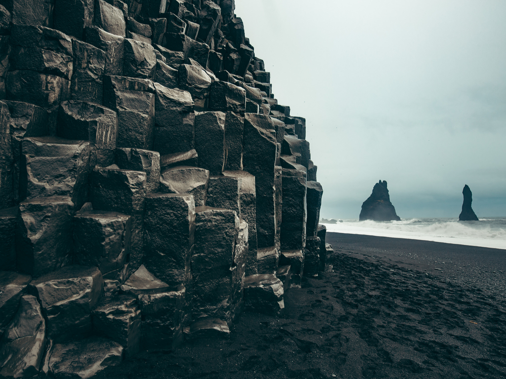
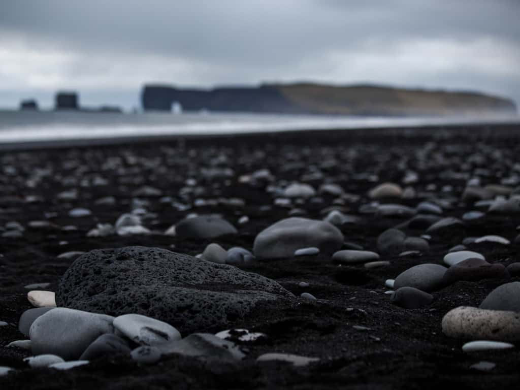
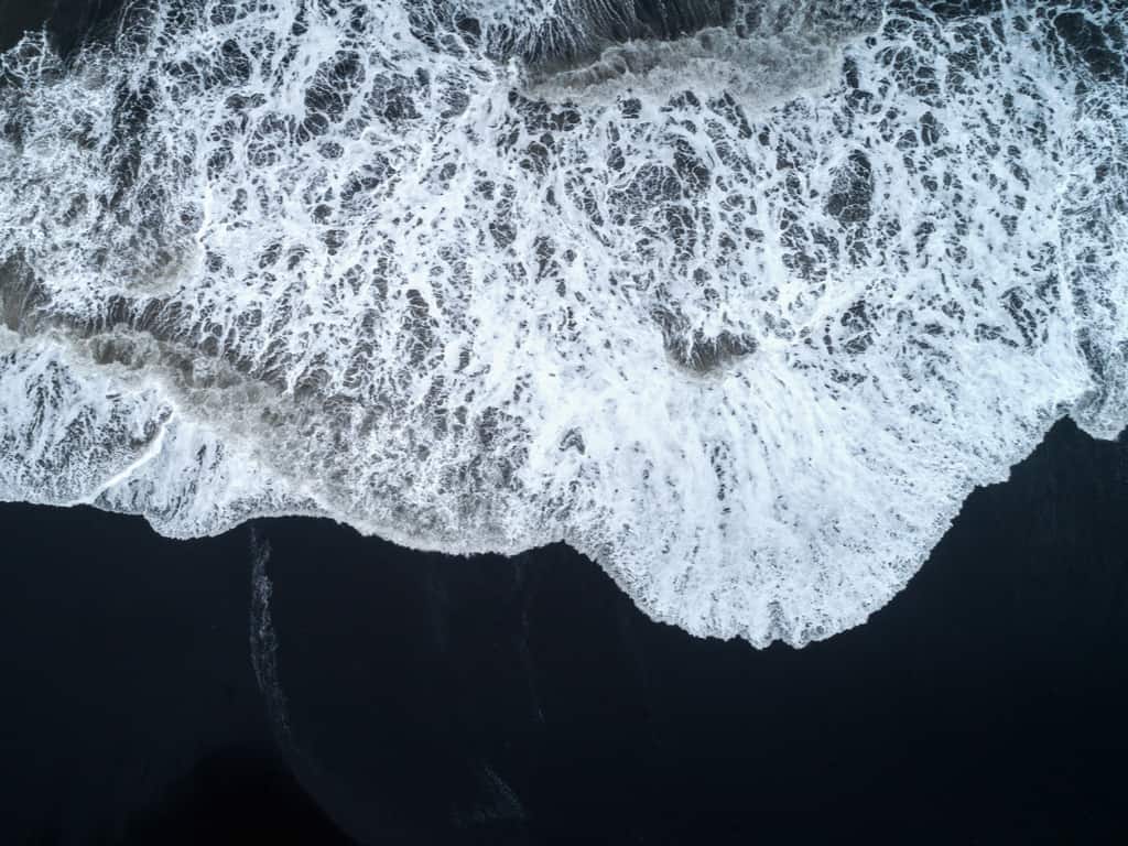
The black sand beach of Vik is the stupendous creation of nature. With the smooth black sand along the sea coast, the mesmerizing, powerful, beautiful, and magical beaches will be classic. The popular arctic country with the most amazing beaches and the mind-blowing environment makes the trip of the black sand beach Vik Iceland memorable.
The cold breeze, clear water, dark-beauty beaches, and the splendid sky above create a paradise in Iceland.
Where is the Vik black sand beach?
The alluring Vik black sand beach is located Iceland’s south coast, about 2.5 hours away from Reykjavik. Located by the beautiful small town of Vik I Myrdal, this beach is no less than a paradise.
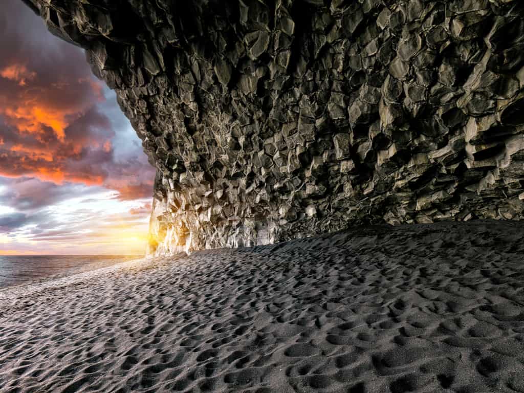
The sparkling black sand, large basalt columns and turquoise blue sea is home to the spectacular biodiversity and various nesting birds. The exclusive home of puffins, guillemots, and fulmars is just mesmerizing and pleasant.
Enjoy a breathtaking sunset at Vik’s Black Beach, where the sky and sea unite in a display of vibrant colors in Iceland
What is the best time to visit Vik black sand beach?
With the natural beauty scattered everywhere and the soothing environment, the black sand beach is breathtaking. With the beauty of cool Iceland and the most dramatic landscapes right from the phenomenal volcanoes to cascading waterfalls, breathtaking ice caves, and mystical mountains, the place is awe-interesting.
Visiting this white fairyland of ice and black sand is incredible throughout the year. The best time for the Black beach of Vik is between 2-5 PM during the day.
Explore the rugged coastline and natural arches near Vik’s Black Beach, a journey through Iceland’s spectacular landscapes.
What types of rocks is the Vik black sand beach made of?
The dark-beauty of nature is alluring and soothing. The volcanic rocks formed after the lava condensed at this place makes it even more beautiful. When the rock starts to get worn, the tiny pebbles are formed. The sparkling turquoise sea, black sand, and crystal clear ice reflecting the rainbow lights create the image of the paradise at the Black beach of Vik.
Witness the majestic Reynisdrangar sea stacks from Vik’s Black Beach, an iconic sight along Iceland’s coastline.
What to do at Vik black sand beach?
The marvelous and classic black sand beach is beautiful in all aspects. With so much to explore and travel, the black sand beach is alluring and phenomenal. With the beauty scattered all around this black sand beach is just thrilling.
The best things to do here are:
Explore the black sand beach
Take a trip of the alluring caves
Visit the enormous cliff of Dryholey
Adore the Diamond Beach
Get amazed with the northern lights
Hike on the Glacier
Explore the Eldhraun Lava Fields
Explore the unique beauty of Vik’s black sand beach, a natural wonder with its striking dark sands and dramatic waves in Iceland.
Where to stay in Vik black sand beach?
Spending time in the lap of nature at the black sand beach Vik Iceland is an awe-inspiring experience. The beauty of the sand and coolness of air creates magic at this place. The best places to stay at this glorious location which offer luxury are:
Black Beach Suites: The best and the modest hotel near the astounding beaches offers the polished stay studios free WiFi, and shared kitchen.
Vik Cottages: The stupefying collection of cottages with countryside views, a restaurant, and a gym.
The Barn: The well-settled line of dorms and private rooms in a warehouse-cum-chic hostel offering a bar, a kitchen, and Wi-Fi, the stay would be pre sheer luxury.
Vik Apartments: The budget-friendly apartments with kitchens, living rooms, and countryside views, topped with high-speed Wi-Fi.
Hotel Kria: The luxurious and modern hotel blended with the authentic Iceland kitchen, and a bar with the free breakfast accompanied by an adoring view of the northern lights, this is amazingly cozy.
The beauty of the sand mixed with the calmness of the sea and cool breeze creates an alluring and phenomenal picture at the Vik black sand beach. Visit this place to explore the untouched beauty of ice and water!
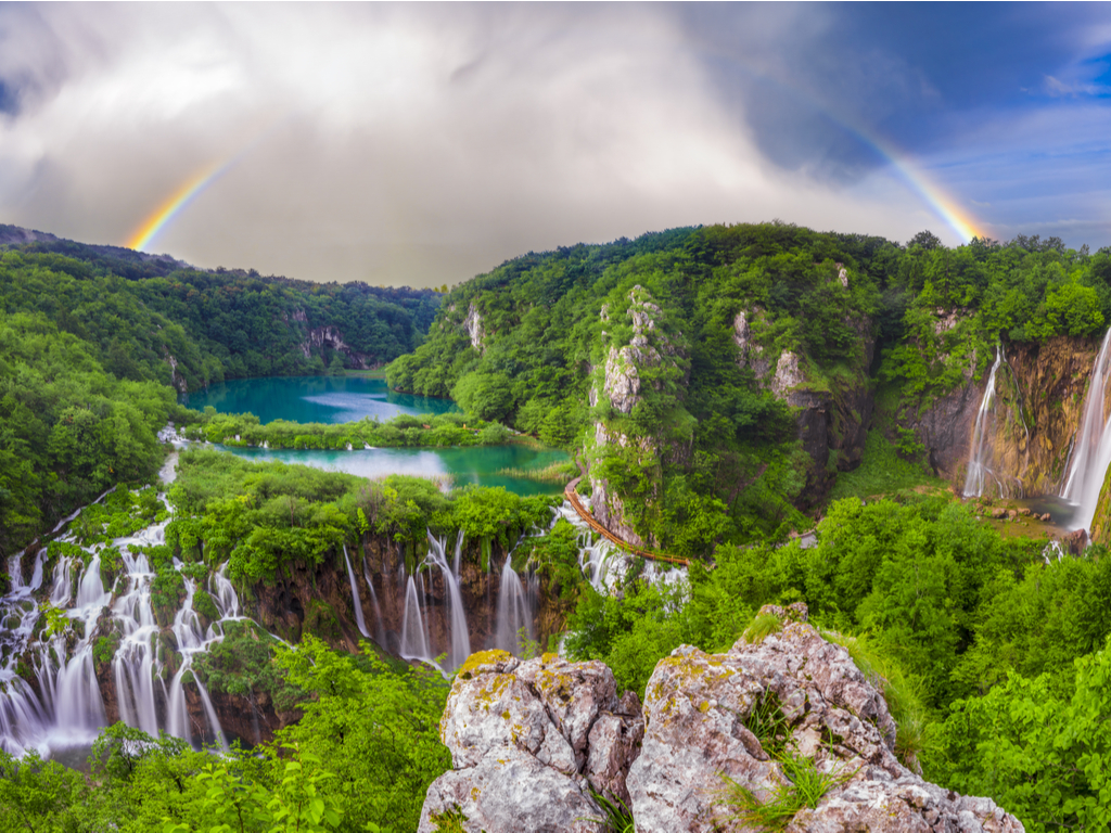
Plitvice Lakes National Park is the crowning jewel of Croatia. The erstwhile chalk and limestone have been overflown with tumultuous waters over several years to create organic dams, Croatia waterfalls, and lakes. The coastline itself spans 1.778 kilometers and a whopping 1185 islands.
The natural beauty of the park is amplified by the surrounding forests that house exotic animals such as wolves and bears.
How to reach Plitvice Lakes National Park?
Here are a few routes that you can take to reach Plitvice Lakes, National Park:
From Zagreb to Plitvice Lakes: You can opt for a connecting bus from the terminal building at the Zagreb Airport to the Zagreb bus station. Take another bus from this station. You will reach Plitvice Lakes within three hours.
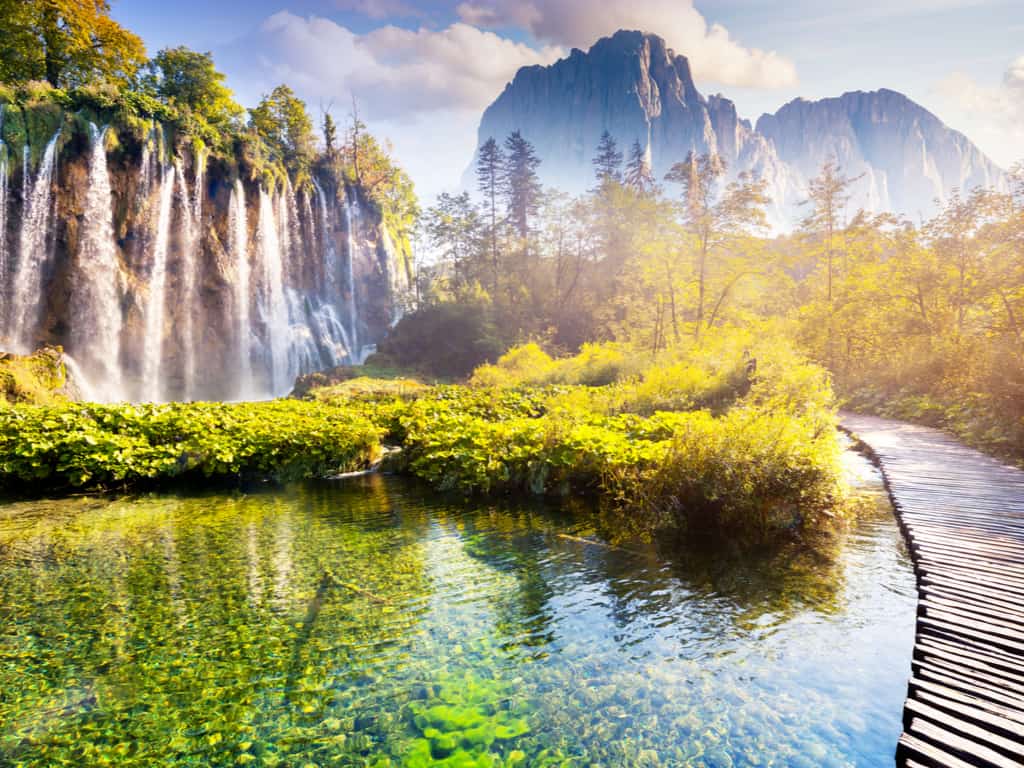
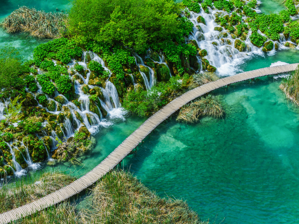
Experience the majestic waterfalls of Plitvice Lakes National Park, a breathtaking natural wonder in Croatia.
From Split to Plitvice Lakes: Buses are the only modes of public transport from Split to Plitvice Lakes. You can also sign up for the organized day tours to reach the Croatia National Park. It will take around four hours to reach Plitvice Lakes from Split through the bus service.
From Zadar to Plitvice Lakes: Plitvice Lakes National Park is approximately 130 kilometers away from the Zadar Airport. You can take a connecting bus from this airport to Zadar Bus Station and then venture toward Plitvice by boarding a different bus. The entire journey spans two hours.
In case you are in any other part of Croatia and wish to visit the Plitvice Lakes, you may board a bus to any of the three locations mentioned above and take another bus once you reach there.
Witness the enchanting morning mist at Plitvice Lakes, a magical start to any day in this Croatian paradise.
When to visit Plitvice Lakes National Park?
Our recommendation will be to visit this Croatia National Park between June and September. There’s a significant influx of tourists between July and August and during the morning hours. The scenery is picturesque and the crowds are sparse from 7 a.m. onwards so you should seriously consider exploring this part during this tranquil time.
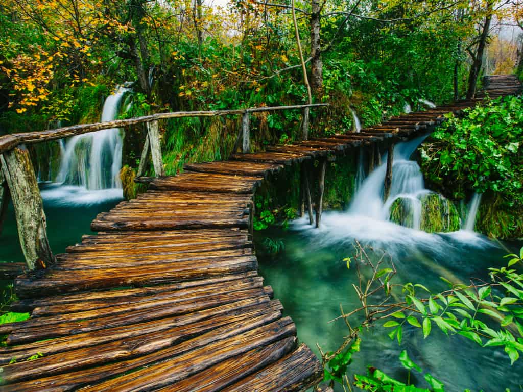
Stroll along the charming wooden paths of Plitvice Lakes National Park for an up-close encounter with Croatia’s natural beauty.
However, don’t let this restrict you. There’s a seasonal perk to visiting this during all seasons – the beauty of the peak of the waterfalls during spring as the water levels increase. On the other hand, fall showcase the wondrously changing colors of nature while winter allows visitors a look at the frozen lakes and the winter wonderland in general.
What should you visit when come to Plitvice Lakes National Park?
It lives up to its status as a UNESCO World Heritage site. The park comprises around 90 waterfalls, lakes that date back to thousands of years, and a diverse ecosystem with different varieties of flora and fauna.
Plitvice is a great place for adventure lovers. You can go hiking on the mountains or forest trails, opt for horse riding or kayaking, or just book a buggy ride.
You can fit in a trip to Smiljan, which is the birthplace of Nikola Tesla, and houses a museum with his mementos. It is only 65 kilometers away, so the opportunity is ripe!
Discover the tranquil turquoise waters of Plitvice Lakes, nestled in the heart of Croatia’s lush forests.
If you wish to kick things up a notch and visit a unique tourist destination that puts you at peace, Plitvice Lakes is the place to be!