Hadrian’s Wall Walks – Fascinating Views Along Ancient Roman Ruins

Sunset casting a golden light over the remains of Hadrian's Wall, stretching across the rolling hills of Northern England.

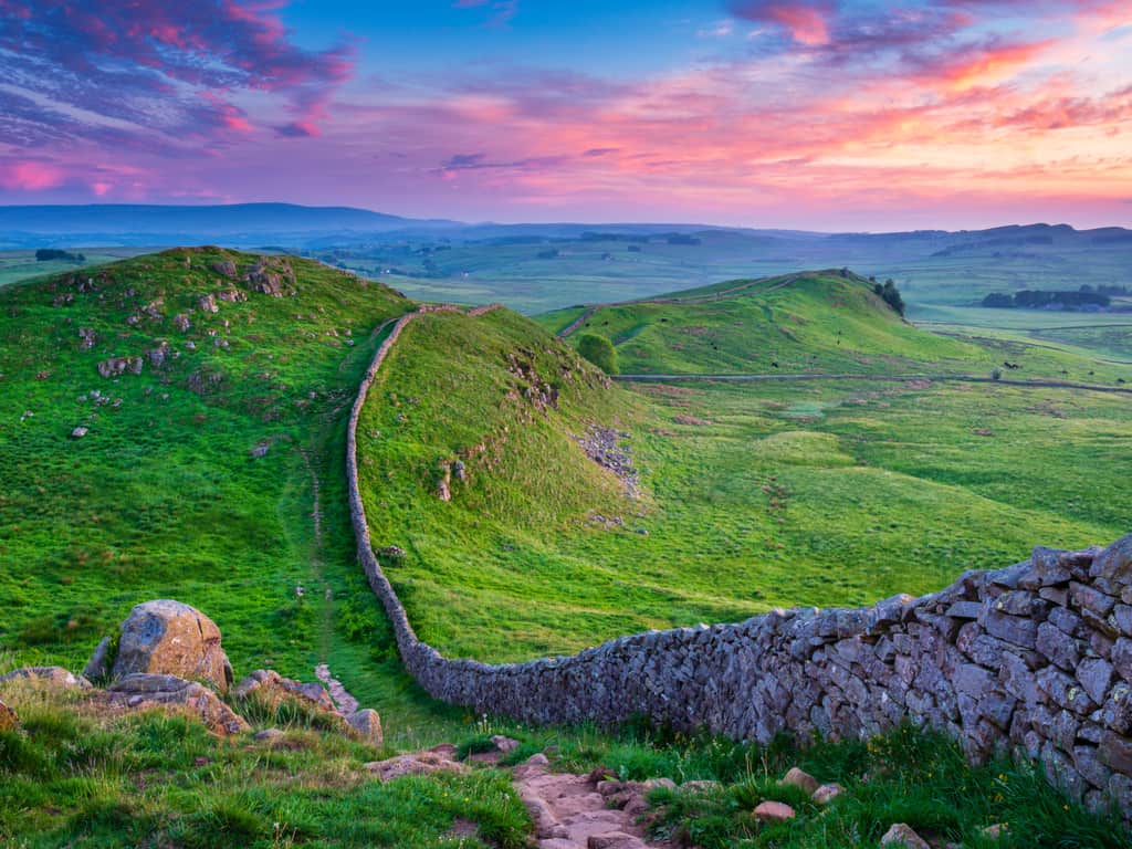
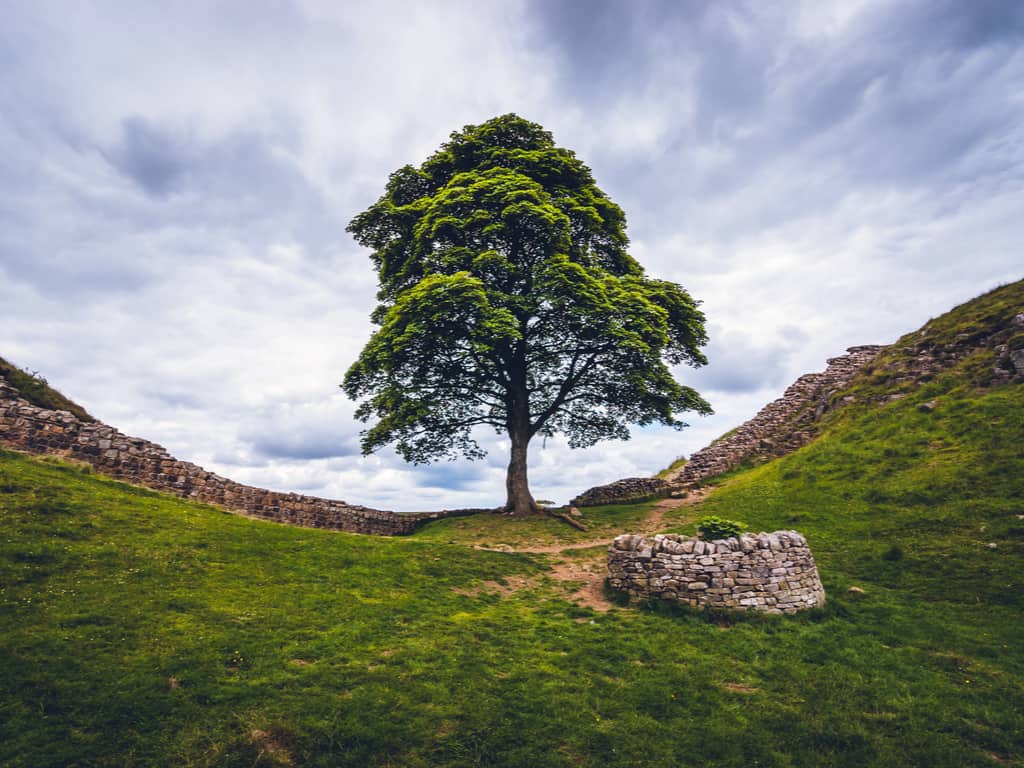
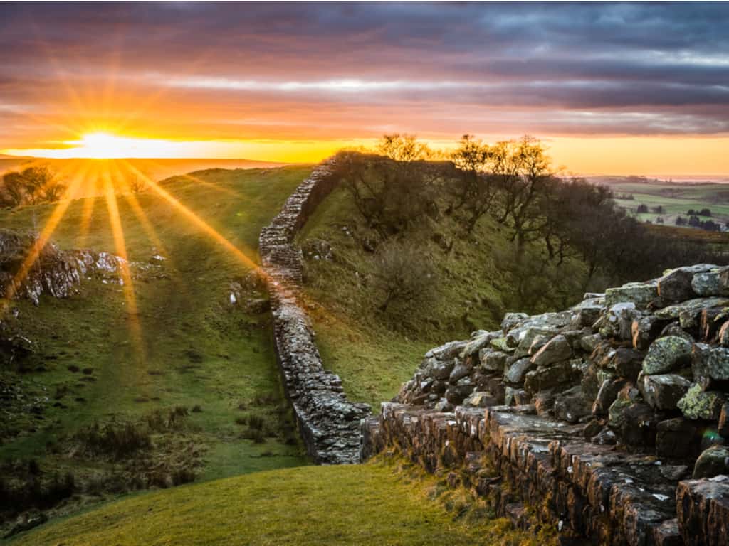
Hadrian’s Wall is a historical boundary formed by a series of stone and turf fortifications, stretching over 70 miles in the North-western English countryside and ideal for hiking.

Hadrian’s Wall is sometimes compared to the Great Wall of China, although it is way shorter and narrower than it.

It is nevertheless an ancient engineering achievement constructed across rugged terrains, rivers, streams, and mountains. It is a fun experience to walk alongside Hadrian’s Wall and visit the museums along the pathway.

The fortresses harboring the barracks and museums, along with the long scenic Hadrian’s Wall walk, make it a must-visit place in the United Kingdom.

How old is the Hadrian’s Wall?

Construction of Hadrian’s Wall began years after Emperor Hadrian ascended the throne in 117 A.D. It was begun in 122 A.D. and completed within six years. Since then it has undergone numerous extensions and additions.

"Interactive exhibits at the Hadrian's Wall visitor center, providing educational insights into the wall's historical context.
Engage with interactive exhibits at the Hadrian’s Wall visitor center, offering educational insights into this monumental work of Roman legacy.

Why was it built?

The Roman Empire had expanded enough, and now with Emperor Hadrian on the throne, it sought to protect what it had acquired so far.

Thus the clear purpose of the Hadrian Wall was to protect the land from the Caledonians and other barbarian troops.

Who built it?

The Wall was built by the Romans on the orders of Emperor Hadrian shortly after their conquest of Britain.

The inscriptions on various sections of the Wall indicate that the British army had Hadrian’s Wall built.

Heavily armed infantrymen worked hard over six years to build Hadrian’s Wall.

The ancient stones of Hadrian's Wall standing resiliently against a dramatic sky in the British landscape.
Marvel at the resilience of Hadrian’s Wall under a dramatic British sky, a testament to the ancient world’s engineering.

How long is Hadrian’s Wall?

Hadrian’s Wall is located near the border between present-day Scotland and England.

It was built in an east-west direction and stretches 73 miles from Wall’s end on the River Tyne in the east to Bowness on the Solway Firth in the west.

Hadrian’s Wall is a great place for walking, and nature lovers with a penchant for ancient stonework will hardly find a more beautiful place anywhere else in the world.

How to plan a Hadrian’s Wall walk?

Essential for planning to walk Hadrian’s Wall is that you determine the direction in which you want to walk it.

The classic route walking Hadrian’s Wall follows the construction of the wall from east to west. This offers several advantages. On the one hand, you observe the change in landscape from the urban hustle and bustle of Newcastle to the idyllic expanses of Northumberland to the final destination by the sea. On the other hand, you follow the course of the sun and are rewarded with atmospheric sky colours and sunsets when the sky is clear.

However, there are also hikers who walk Hadrian’s Wall from west to east and thus have the Atlantic wind at their back. Be sure to determine the direction at the beginning of your trip planning.

The sycamore tree at Sycamore Gap, Hadrian's Wall, known from the film 'Robin Hood: Prince of Thieves'.
Visit the iconic Sycamore Gap at Hadrian’s Wall, made famous by ‘Robin Hood: Prince of Thieves’, a natural landmark steeped in cinematic history.

How to get to there?

All set to walk Hadrian’s Wall along the footsteps of an ancient Roman soldier?

If you happen to start from Newcastle, we highly recommend taking a train from Newcastle to the Hexham town, followed by catching Hadrian’s Wall Country Bus AD 122. This route covers the major part of the Wall.

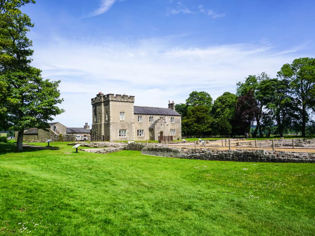
You also get to see the forts of Housesteads and Vindolanda and the Roman Army Museum close to greenhead. Thus you get to visualize the Wall in a spectacular setting.

Also, there are beautiful and scenic stretches of the Wall near Cawfields and Steel Rigg in the Northumberland National Park, England.

Hadrian’s Wall facts

Emperor Hadrian’s successor Antoninus Pius built yet another wall named the Antonine Wall, located in modern-day Scotland. He abandoned the Hadrian’s Wall and established his center elsewhere in the Antonine Wall. Subsequently, this Wall was abandoned as well, following its failure in defending from the nomadic.

Only 10% of the ancient Wall is currently visible. The Wall has suffered a lot of damage in the past 2,000 years. They were mined for stones to build churches and buildings.

Sunset casting a golden light over the remains of Hadrian's Wall, stretching across the rolling hills of Northern England.
Watch the sunset bathe Hadrian’s Wall in a golden glow, highlighting the enduring legacy of Roman Britain.

There is sufficient convincing evidence for historians to believe that a lot of archaeological sites are yet to be discovered in the vicinity of the Wall in the Hadrian’s Wall map. This fascinating ancient landmark was finally designated as a UNESCO World Heritage Site in

Valensole – See the unique land of Mediterranean Fragrances

Immerse yourself in the tranquil beauty of the Valensole lavender fields, a sea of purple set against the idyllic Provence landscape.

Valensole is a surprisingly beautiful plateau filled with the kaleidoscopic swirl of lavender purple and gold. Starting from what are the best things to do in Valensole to the best time for visiting this place, we have included everything in this article for you to understand this beautiful place.

With the fragrance of lavender in the air and the sky filled with shades of pink, this place is a dreamland.

The dreamland of romance and beauty situated at an altitude of 500 meters to the south of the Alpes-de-Haute-Provence, near Digne-Les-Bains and the Verdon gorges, this place is pure heaven. With amazing lavenders fluttering all over, and the lovely landscape, the dreamland of Valensole France, is a startling destination for photographers and lovers.

How to go to Valensole?

The stunningly beautiful and marvelous city of Valensole is ready to take you to dreamland at any point in time. With the lavenders fluttering and dancing, the sky filled with shades of pink, the air filled with sweet fragrance, and the romantic atmosphere everywhere, Valensole France is phenomenal and glorious.

Endless rows of blooming lavender at the Valensole Plateau, with a picturesque Provence landscape in the background.
Immerse yourself in the tranquil beauty of the Valensole lavender fields, a sea of purple set against the idyllic Provence landscape.

To reach this magnificent city the best options are:

Close-up of vibrant lavender flowers in bloom in Valensole, showcasing their delicate beauty.
Discover the delicate beauty of blooming lavender up close in Valensole, a sensory delight in the heart of Provence.

When to go to Valensole?

With the beginning of summer, the beauty of the lavenders starts spreading across the trails of the city. With the surprising Valensole Lavender fields, spread throughout the place looks like heaven in purple and gold on earth.

At the end of June and the beginning of July, when the lavender flowers are in full bloom, the Valensole city becomes perfect to welcome the tourists with the purple glory spread all-over.

What to do in plateau de Valensole France?

The land of Valensole is a sparkling beauty. The sheer calmness of flowers smiling at you, and the pink sky above your head, the place is just mesmerizing. With lavender fields spread all over, and the breathtaking view, the hearts of the tourists are sure to skip a beat.

To capture the beauty of the place at once and to surprise the soul, the best things to do at Valensole France are:

  • Visit the Valensole lavender fields at ‘Route de Riez’
  • Attend the Valensole lavender festival
  • Explore the Chapelle Saint-mayeul
  • Dine at Le Jardin De Celina
  • Admire the Eglise Saint-Blaise et Notre-Dame-des-Malades
  • Take a sip of Clos De Villeneuve
"Traditional stone farmhouse surrounded by the purple lavender fields of Valensole, embodying rural French charm.
Explore the charm of a traditional stone farmhouse nestled amidst the lavender fields of Valensole, a quintessential Provence experience.

What is the best time for Lavender photos?

With beautiful lavender fields and purple and gold flowers, the picture clicked at the Valensole are awe-inspiring and jaw-dropping. The place is the perfect destination for photographers who wish to capture nature in their lens.

Between 6:30 to 10PM in the evening, when the sunsets and the sky is filled with hues, the glowing sparkle of sunlight, and the beautiful lavenders dancing around, the time to capture the picture of the Valensole lavender fields will be extraordinary.

When is the Valensole Lavender festival?

The breathtaking view of the Lavenders is spread all across the city. With infinite beauty and jaw-dropping scenes, the place is just unbelievable. The Valensole lavender fields spread across the endless, and under the sparkling sunlight and cool breeze, the place is perfect.

The Lavande Angevin is the best and the coolest Valensole lavender fields to visit. The beauty of the lavender is celebrated in the Valensole Lavender festival on 3rd July every year.

Immerse yourself in the tranquil beauty of the Valensole lavender fields, a sea of purple set against the idyllic Provence landscape.
Experience a magical sunset over Valensole’s lavender fields, where the sky and flowers blend in a canvas of colors.

The fairyland of lavender, spreading joy and beauty, with the purple flowers smiling and spreading their fragrance, the city of Valensole France is phenomenal. So plan your trip to the Valensole lavender fields to capture its beauty, and create a life time memory here!

Giant Hand Bridge – Love this classic piece of Art in Nature

Tourists walking along the Golden Bridge, enjoying panoramic views of the surrounding mountains.

The Giant Hand Bridge of Vietnam is a manmade marvel standing on the Ba Na hills. The architectural beauty of the giant hands attracts tourists from all over the world. Holding the long and beautiful bridge above 1400 meters sea-level makes this bridge worth watching.

Traveling across the bridge and exploring the nature that surrounds, the beautiful skies above and the forest beneath, makes Vietnam Golden Bridge stupendously beautiful and breathtaking.

Read the entire article to know more about the Giant Hand Bridge and the alluring beauty that surrounds it.

Where is the Vietnam Golden Bridge?

The 150-meter long architectural marvel of Vietnam, Golden Bridge is located at Sun World Ba Na Hill, Hoa Phu, Hoa Vang, Da Nang, Vietnam. This beautiful and sensational piece of architecture with a perfect curvy shape and style makes this bridge a perfect beauty.

Holding the bridge above 1400 meters sea-level allows the tourists to experience the cool breeze and praise the green nature around. Walking through the giant hand will give you butterflies in the stomach.

How to get to the Vietnam Golden Hand Bridge?

The marvel of human, Golden Hand Bridge sits on the top of a mountain in Ba Na Hills. The only way to reach here is by cable car. The cable car runs from Sun World to this beautiful golden bridge. 

Misty morning view of the Giant Hand Bridge, creating a mystical atmosphere in the Ba Na Hills.
Witness the mystical beauty of the Giant Hand Bridge in a misty morning setting, a magical moment in Vietnam’s Ba Na Hills.

To reach to the Ba Na Hills on foot the transportation facilities are:

  • To travel from Da Nang center/Hoi An to Ba Na Hills foot one can select a motorbike, shuttle bus, taxi, private car, or can join a tour
  • From Ba Na Hill get a ticket for the cable car and reach the top to amaze yourself.

What makes the Golden Bridge with Giant Hands so astonishing?

With the elegant design and classy structure, the golden bridge is an astonishing piece of art. The giant hands holding the bridge in the middle of the forest and below the open sky make this place just amazing.

With the beauty surrounding the place, and the majestic views that it offers, the Vietnam Golden Bridge with its giant hands is a splendid piece of art. The harmonious blend of groundbreaking architecture and spectacular nature is a perfect place to troll around. The out-of-the-world architecture is so picture perfect.

Close-up of the intricate design and details of the giant stone hands supporting the Golden Bridge.
Admire the intricate details and craftsmanship of the giant stone hands that hold up Vietnam’s renowned Golden Bridge.

What is the story of Golden Bridge?

The startling piece of architecture, Golden Bridge is located on the top of the Ba Na hill. This classy golden bridge is 150 meters long and is above 1.400 meters above sea level. The two big giant hands holding abridge that allows the passers to talk to the sky and explore the infinite beauty of the land beneath makes this bridge surreal.

The golden strips gave this place it’s the beautiful name as Golden Bridge.  The majestic and impressive scene similar to ones like Game of Thrones or The Lords of the Rings makes the beauty of the Vietnam Golden bridge extraordinary. This bridge is the new symbol of tourism in Danang Vietnam.

Who made the Giant Hands?

The classic piece of art talking to the sky and gazing at the forest was built by TA Landscape Architecture of Ho Chi Minh City. 

The founder of the company Vu Viet Anh, with designers Tran Quang Hung and Nguyen Quang Huu Tuan, designed this phenomenal Golden Bridge in Danang Vietnam.

The elegant piece of architecture, holding the bridge high up in the sky with the majestic view, makes the Golden Hand Bridge of Vietnam Just a picture-perfect site to visit. It is one of the most highly recommended places to visit!

Tourists walking along the Golden Bridge, enjoying panoramic views of the surrounding mountains.
Stroll along Vietnam’s iconic Giant Hand Bridge and take in the breathtaking panoramic views of Ba Na Hills.

Where to stay when visiting Da Nang?

Below are our top recommendations for a comfortable stay in Da Nang. 

HAIAN Beach Hotel & Spa – Lovely location at the beachfront with a beautiful view from the hotel room.

Maximilan DaNang Beach Hotel – New hotel with clean, modern rooms. Great location opposite the beach with easy access to the town center and river area.

Novotel Danang Premier Han River – Luxury hotel with two restaurants and amazing views of the Han River.

Aerial view of the Golden Bridge and its lush green mountainous backdrop in Vietnam.
From above, the Golden Bridge in Vietnam appears as a golden thread through lush green mountains, held by mighty stone hands.

The Galapagos Islands – Heart Warming and Adventurous

Giant Galapagos tortoises roaming freely in the lush highlands of Santa Cruz Island.

The Galapagos Islands are a group of isolated volcanic islands and tiny islets sprinkled in the Pacific Ocean. Friendly wildlife along with the scenic beauty of this archipelago is responsible for its top position in most bucket lists.

Galapagos Islands Animals – your pals during your Galapagos Holidays

Thanks to its remote location and equatorial position in the Pacific, the Galapagos Islands harbors magnificent flora and unique wildlife. The vivid ecosystem of the Galapagos Islands had inspired Charles Darwin’s theory of Evolution.

A mother seal and her pup resting on the rocky shores of the Galapagos, a tender natural moment.
Witness the tender moment between a mother seal and her pup on the rocky shores of the Galapagos Islands.

Not to forget, the beloved, adorable, and incredibly friendly Galapagos Sea lions are another major attraction along with the quiet and peaceful Galapagos fur seals. The only category of penguins to live in the north of the equator, the Galapagos penguins are a very rare sight to see – consider yourself fortunate if you do.

It is impossible to mention all these lovelies in one go, from bottlenose dolphins to golden stingrays, blue-footed boobies and albatross; oh my!

How many Galapagos Islands are there?

There are about 130 islands, of which 13 are larger and four are smaller islands above Galapagos hotspot.

The first islands formed here at least 8 million years ago, but possibly much earlier. While the older islands have eroded over time and disappeared back into the sea.

A Galapagos penguin swimming gracefully near Isabela Island, a rare sight in the tropical region.
Spot the rare Galapagos penguin swimming near Isabela Island, a unique encounter in this tropical paradise.

However, the approximately 25,000 inhabitants are only found on the five inhabited Galapagos Islands:

San Cristobal with the port Puerto Baquerizo Moreno which is also the provincial capital with 8.000 inhabitants;

Santa Cruz with the largest city of the archipelago, Puerto Ayora and 15.000 inhabitants;

Isabela with the port Puerto Villamil and 2.000 inhabitants;

Floreana with the port Puerto Velasco Ibarra and 120 inhabitants;

Baltra Island, where there is an airport and a small naval station.

Another 17 islands of the archipelago can be visited extensively during a Galapagos trip or cruise.

How to get to the Galapagos Islands?

First of all, you need to arrive at the mainland of Ecuador by landing either at Guayaquil or the capital city of Quito – Guayaquil’s Jose Joaquin de Olmedo International Airport or Quito’s Mariscal Sucre International Airport. Guayaquil seems to be more convenient for most travelers.

Most tours and cruises start from Santa Cruz Island. So you got to fly to Baltra Island first, from Quito or Guayaquil and then take a scenic ferry ride to Santa Cruz Island. It’s now time to head on to your tour.

Marine iguanas basking on the sun-drenched rocks of the Galapagos shoreline.
Marvel at the unique sight of marine iguanas sunbathing on the rocky shores of the Galapagos, a distinctive feature of the islands.

What to do at the Galapagos Islands?

You have to get your hands on Galapagos Island tours, months before your journey. They are high on demand and sell off really fast. They must include the following:

  • Snorkeling and diving.
  • Wildlife watching
  • Hiking – who wouldn’t want to trek over dried lava beds!
  • Kayaking – rent out a kayak at Tortuga Bay, Santa Cruz, you don’t even need a guide for this
  • Volunteer for some eco-friendly activities like farming and habitat restoration campaigns

The Galapagos holidays are a dream adventure for many travelers out there. Take a few days off and spend some wonderful time with friends or family, exploring the diversity of the group of islands.

Giant Galapagos tortoises roaming freely in the lush highlands of Santa Cruz Island.
Encounter the iconic giant Galapagos tortoises in their natural habitat on Santa Cruz Island, a highlight of Galapagos wildlife.

Where to stay when visiting the Galapagos Islands?

You might have to spend quite a few days here since there is so much to explore and enjoy. Below are our top recommendations for a comfortable stay at the Galapagos Islands.

Albemarle – Simple beachfront lodging, with antique wooden ceilings and a swimming pool area.

Royal Palm Galapagos – Perfect for a relaxing and exotic night stay.

Galapagos Morning Glory – Apart from the beachfront view, it gives access to a commercial area featuring stalls and banks.

Angermeyer Waterfront Inn – Minutes of walking away from the shore, and has an elegant design.

Villa Escalesia – Stunning villa with your very own private outdoor pool. Situated directly at the beach, providing a landscape view of a vast stretch of the Pacific.

Cliffs of Moher – See Ireland’s famous Cliffs with legendary Tales

Sunset over the Cliffs of Moher, casting a golden glow on the rugged coastline.

Quite a many folklore stories surround the high standing cliffs: One of them says that once upon a time, an old hag called Mal fell in love with CúChulainn, the Irish hero. The man had no feelings for her, and she kept looking for him everywhere in Ireland. Upon finally being cornered by Mal, the man managed to escape. During the encounter, Mal lost her leg, was dashed against the cliff, and fell into the sea, which turned bright red.

The fascinating Cliffs of Moher are by far one of the most famous tourist attractions of Ireland. It feels no less than a painting on a canvas.

Where are the Cliffs of Moher?

Stretching to as far as 14 kilometers, the Cliffs of Moher are high rising sea cliffs situated at the southwestern brink of the Burren region in County Clare, Ireland.  The cliffs’ maximum height is a jaw-dropping 214 meters or 702 feet at the northern end, just north of the O’Brien Tower.

The Cliffs of Moher shrouded in mist, creating a mystical and atmospheric landscape.
Witness the mystical side of the Cliffs of Moher as they are enveloped in mist, adding to the magic of the Irish landscape.

How to get to Cliffs of Moher from Dublin?

Families and college students usually rent a car while moving from Dublin to the Cliffs of Moher. To get to the cliffs, follow R148 before continuing on N4. Then continue on M6 and keep following the signs to Galway. The journey would take around 3 hours.

Lonely wanderers out there might want to use a bus. Take the 300 bus from Burgh Quay to Dunnes/ Friars Walk in Ennis/ Dublin City South. Then walk to the Enmis Bus Station and take the 350 bus and get down at Cliffs of Moher stop.

Aerial view of the Cliffs of Moher, showcasing their impressive scale and the surrounding green landscape.
From above, the Cliffs of Moher reveal their grand scale, towering over Ireland’s lush, green landscape.

What is special about the Cliffs of Moher?

Just do not look down! It goes downhill almost vertically. The cliffs are up to 214 meters or 702 feet high. Some visitors venture beyond the barrier of stone slabs directly to the edge of the cliff. But this is not really necessary to admire the beauty of the best known steep cliffs of Ireland.

The Cliffs of Moher are also famous for their flora and fauna and the impressive animal world. Especially bird lovers are often drawn to this impressive place to watch peregrine falcons or kittiwakes.

The cliffs are not only popular with travelers, they also served as a backdrop for the filmmakers of the Harry Potter series. Furthermore, some scenes of the movie “The Princess Pride” and “Ryan’s Daughter” were shot here.

Dramatic waves crashing against the base of the Cliffs of Moher, showcasing the power of nature.
Feel the power of nature as waves crash against the base of the Cliffs of Moher, a dramatic and awe-inspiring sight.

Hiking trail at the Cliffs of Moher

Hikers have a nice alternative to the trip to the official viewpoint. From Doolin in the north to Liscannor in the south, there is a 20 kilometer or 12.5-mile hiking trail right along the cliffs.

Well, what is called a hiking trail. It is more like a trail past sheep and cows. But always with the impressive view of the Atlantic Ocean. Impressive.

Trivia to know before visiting the most popular cliff in Ireland?

It is a fact that the cliff has been a recognizable and familiar backdrop on the big screen. Some movies and TV shows featuring the cliff are Harry Potter and the Half-Blood Prince, The Mackintosh Man, The Yank, Father Ted, Into The West, and many more.

UNESCO votes this picturesque Irish landscape to be the seventh most wonderful Heritage Site of the World.

Sunset over the Cliffs of Moher, casting a golden glow on the rugged coastline.
Catch a breathtaking sunset at the Cliffs of Moher, where the sky and sea merge in a spectacle of golden hues.

Where to stay near Cliffs of Moher?

Kate’s Country Cottage: The hotel is close to the breathtaking cliff, so you would have no problem while walking the distance.

White Waves Cottage: This one is just 20 minutes away from the high-rising cliffs and provides you some stunning sea views.

The Townhouse: A fabulous stay, only 8 miles away and available for a convenient price. This lodging additionally offers a private garden for a fun and cozy stay.

Castlefergus Lodge: Get some beautiful panoramic views of the surrounding ocean and countryside, being very close to the cliffs.

Be Enchanted by The Mysterious Chocolate Hills of The Philippines

Panoramic view of the Chocolate Hills in Bohol, Philippines, showcasing their distinctive conical shapes

The chocolate hills of Bohol are a significant tourist attraction in the Philippines. These chocolate mountains were formed naturally on the island of Bohol in the Philippines over millions of years.

From lush green in the rainy season, colors change to chocolate brown as soon as the dry season arrives.

Some 1,700 chocolate mountains extend across 20 square miles, rising as high as 400 feet – these Chocolate Hills of the Philippines never fail to amuse tourists. 

What is the story of Chocolate Hills, Bohol?

The said stories of how the hills formed are quite funny, to be honest. Some say that two giants fought by hurling rocks, sand, and boulders at each other. The fight subsided, and they became friends, after fighting in this way for days. They left but forgot to undo the mess they created! This is how the hills came to be.

Another legend with a romantic inclination suggests that a powerful and youthful giant named Arogo once fell in love with Aloya, a simple mortal human being. Aloya somehow died, and Arogo ended up sobbing for days. His tears after drying formed the Chocolate Hills of Philippines.

Aerial view of the Chocolate Hills, revealing their extensive spread across the Bohol landscape.
Experience an aerial perspective of the Chocolate Hills, revealing their extensive and mesmerizing spread across Bohol’s landscape.

How were the Chocolate Hills of the Philippines formed then?

The land’s limestone base came to existence from the skeletons of sea life. Geological processes gradually lifted the Bohol’s rock, and now water slowly erodes it. 

The thing is that weathering is known to carve out limestone all over the world, but the uniformity of shape is what makes the hills unique. Even geologists have not yet concluded this matter.

"Close-up of the grass-covered Chocolate Hills, resembling giant molehills against a blue sky.
Marvel at the close-up view of the grass-covered Chocolate Hills in Bohol, resembling giant natural sculptures under the blue sky.

Chocolate Hills viewing platform

The highest hill, at about 120m, is 5km from the village of Camen. On this hill a viewing platform has been built, from which you have a wide view over the Chocolate Hills.

To enjoy this stunning view, a certain amount of effort is required from the visitor. There are still 214 steps to climb before you can overlook the wide expanse of the Chocolate Hills on the crest of the highest Chocolate Hill.

The hills are covered with hard grass and low bushes, which turn brown at the end of the dry season. This color and the even shape of the hills gave rise to its name. At other times of the year, however, the hills are green and an association with chocolate only occurs in the minds of visitors. This does not detract from the admiration, on the contrary, many people decide to come back in the dry season to see the Chocolate Hills in their chocolate color.

Lush greenery surrounding the Chocolate Hills during the rainy season, enhancing their beauty.
Visit the Chocolate Hills during the rainy season to see them surrounded by lush greenery, enhancing their natural beauty.

How to get to Chocolate Hills of Bohol?

From Tagbilaran
Get on a bus at the Tagbilaran Mall bus station to Carmen city and get off at the Chocolate Hills stop. From here, it is a walkable distance from the ticket office. You may also hire or rent a car to the ticket office. ‘Habal-Habal’ transport is another option.

From Tubigon
While hiring motorcycles and tricycles rides are a more convenient option, you can also first go to Carmen city by bus and then follow the same route as above. You get buses to Carmen from Tubigon bus terminal. 

From Alona Beach
It’s better to book a tour from here. Well, you may also follow the route from Tagbilaran to Carmen by first going to Tagbilaran.

Panoramic view of the Chocolate Hills in Bohol, Philippines, showcasing their distinctive conical shapes
Explore the iconic Chocolate Hills of Bohol, a unique geological formation that captivates with its symmetrical conical shapes.

Where to stay near the Chocolate Hills, Bohol?

Providence Travellers Inn und Spa: Hostels are perfect for solo travelers and students. This one is located in Tagbilaran, has a swimming pool, restaurant, garden of its own.

Villa del Carmen Bed & Breakfast: At a very comfortable and intriguing location in Carmen, in direct neighborhood to the chocolate hills.

Henann Resort Alona Beach: For those who like it a little more luxurious. Visit the chocolate hills, with your base at the world-famous Alona Beach.

Final thoughts

Around Bohol, some hills are terraced and others form farmland. It is interesting to note that a similar pattern of islets lies just off the coast of the main island. Will these unique deposits of our earth, which have been formed over millions of years, eventually unite? What do you think? 

First of all, the Chocolate Hills have been declared the third national geological monument of the country – which is great. But we can’t wait for them to receive the UNESCO World Heritage designation as well. 

Chiang Mai – Explore this Hidden Gem with its Misty Mountains

Aerial view of Chiang Mai city at dusk, with ancient temples and modern buildings.

The land of the misty mountains, under the clear sky, and the colorful hill tribes, Chiang Mai Thailand is mesmerizing. With this article, let us try to explore more about the breathtaking city.

With the mountains covering the city, the serene beauty of the sunset and the sunrise, creates an alluring effect throughout the land. A paradise for shoppers and nature lovers, Chiang Mai is a destination to impress everyone that visits here.

From the best things to do, best places to stay, and when to visit Chiang Mai, we have included everything in this article for your convenience, keep reading to find more.

The beautiful temples of Chiang Mai, the historical capital of the old Lanna Kingdom, and the verdant valley on the bank of Ping River, the blissful city of are ready to fill with love and amazement.

Where is Chiang Mai?

The misty land of mountains and the city of old historical sites, the land of Chiang Mai in Thailand, is located 700 km north of Bangkok, near the highest mountains including, Doi Inthanon.

Because of its beautiful location surrounded by mountains, the city is also lovingly called “Rose of the North” by Thai people. It is the center of the old Lanna kingdom, which is also known for its handicraft. A fascinating old town with numerous cultural sights and breathtaking nature in all directions.

The cultural beauty and the beauty of nature, the hues of red-orange spread by the sun on the land make this place a paradise.

Lush rice terraces and rural landscapes in the countryside surrounding Chiang Mai.
Explore the picturesque countryside around Chiang Mai, where lush rice terraces paint a serene rural landscape.

How to get from Bangkok to Chiang Mai?

To ensure that you arrive safely and safely, you will find our recommendations here. You can choose between a plane, train, and bus. All details and advantages you can read in the following:

Arrival by plane
The city of Chiang Mai is approached several times daily by the airlines Thai-Airways, Bangkok-Airways, Air-Asia and Nok-Air. The flight duration takes one hour from Bangkok and costs about 1,800 to 3,600 Baht (60-120 USD). There are not yet direct flights from the south of Thailand. Here always a stopover in Bangkok is necessary.

Arrival by train
From Hua Lamphong Central Station in Bangkok, there are daily trains to Chiang Mai station. At night, 1st and 2nd class travel are possible with a sleeping berth and air conditioning and fan. During the day only 2nd class with fan and air conditioner. The 800 km journey takes about 9 to 11 hours and delays are to be expected regularly. The prices are about 800 Baht (25 USD). Night trains should be booked early because sleeping places are very popular.

Arrival by bus
From Bangkok, several buses also leave daily for Chiang Mai. There are scheduled buses and VIP buses available from Bangkok’s northern bus terminal Mo Chid. The journey time is approximately 12 hours including stops for getting off and eating. The prices are about 350 to 500 Baht (12-15 USD) and are definitely the cheapest way to travel but not the best because it is uncomfortable and takes so long.

Recommendation: Flying is by far the most expensive way to travel to Chiang Mai city but also the best and therefore our recommendation. For backpackers, we recommend the train because it is cheap and comfortable.

Magnificent Buddha statue at Wat Phra Singh, a revered temple in Chiang Mai, Thailand.
Admire the serene Buddha statue at Wat Phra Singh, reflecting the spiritual essence of Chiang Mai.

What to see in Chiang Mai?

The sparkling beauty of the clear sky bestowed upon the mountains, and the alluring colorful hills are just splendid. With so much to explore, this place is flabbergasting.

Things to put on your itinerary:

  • Visit the Doi Suthep, the regal mountain
  • Explore the Old City
  • Go for the Night Safari
  • Explore the Elephant Sanctuary
  • Visit Wiang Kum Kam, the underground ancient city
  • Visit Doi Inthanon, the highest peak in Thailand
  • Get mesmerized by Karen Long Neck Tribe & Chiang Dao Cave
  • Visit the Bo Sang Handicraft Village
  • Visit the Lanna Folklife Museum
The ancient Wat Chedi Luang temple in Chiang Mai, Thailand, with its magnificent chedi and intricate carvings.
Explore the historical Wat Chedi Luang in Chiang Mai, a testament to the city’s rich cultural and architectural heritage.

When to visit Chiang Mai?

The stunning and sparkling weather between October and April, with the soothing cool and pleasant temperature and with a light breeze, is the perfect time to book your travel to Chiang Mai Thailand.

Where to stay in Chiang Mai?

The land of amazement and the stunning mountains offers the best in class stay and luxury at the same time.

Some of the best places to stay are:

Le Meridien: 5 km from the airport, the hotel is a blend of Le Meridien’s European heritage and local Lanna style.

Na Nirand Romantic Boutique Resort: The charming hideaway at 5 minutes away from the Night Bazaar and 15 minutes by car to the Chiang Mai International Airport, is the best in the class luxurious stay.

Art Mai Gallery Hotel: Art Mai Gallery Nimman Hotel, is decorated with paintings and intrinsic art to mesmerize the guests. The 4-star hotel is budget-friendly too.

De Lanna Hotel: This hotel is full of modernism blended with tradition. With an outdoor pool and pleasantly furnished suites, this hotel is bliss to stay.

Eastin Tan Hotel: Located at Huay Kaew and a few minutes away from Nimanhemin Road Shopping, this hotel is the most relaxing and friendly in terms of budget.

Aerial view of Chiang Mai city at dusk, with ancient temples and modern buildings.
Behold the beauty of Chiang Mai from above at dusk, where ancient temples blend seamlessly with modern urban life.

The beautiful city of mountains blended with the splendid hues of sunrays, the sunrise, and the sunset is just flabbergasting.  With the beauty of the city and the charismatic aura, traveling to Chiang Mai in Thailand will be remarkable. So book your travel to this amazing place to experience some fantastic beauty and adventure.

Canola Flower Fields – See China’s stunning fields of gold

Aerial view of the geometric patterns formed by the Canola Flower Fields, showcasing their scale and beauty.

The Canola flower fields in China are vast stretches of land that transform annually into an unbelievable golden yellow landscape.

In early spring, wild yellow flowers having rapeseed or canola, bloom and the whole stretch of land look like the shore of a golden sea stretching beyond the horizon, as far as the eye can see.

These blossoming yellow flowers are such a beautiful sight to see.

Where are the Canola Flower Fields in China?

These beautiful fields of yellow flowers are found in Luoping, in the Yunnan province of southern China.

Out of all the canola fields, the best and the most famous place to see the canola flowers is Jinjifeng.

It’s just a few miles outside the main town and is easily accessible by bus. The flat golden yellow fields are interrupted by peaks here and there to break the monotony

Vast Canola Flower Fields in China, blanketed in bright yellow blossoms under a clear blue sky.
Experience the vibrant beauty of China’s Canola Flower Fields, a sea of bright yellow blossoms under the open sky.

When to get to the canola flower fields?

The perfect time to visit looping for this visual feast is during February and March. The show is completely over by June! But beware of bees, as the fresh scent of the canola flowers attracts thousands of bees, and this can be irritating at times. But hey, not only do you get to see the magnificent canola flower fields, but you also get to taste wild and raw honey, all freshly prepared during these two months.

Spend your day here and explore these large natural gardens and engage in the local fests that are ongoing.

What else to do while you visit these Canola Fields?

Since you have come all the way, you shouldn’t miss out on some really scenic places in and around Luoping. A day or two is sufficient to spend on visiting the canola flower fields.

You may then engage yourself in:

  • Duoyi River lookout.
  • Visiting the Jiulong waterfall and clicking some amazing pictures.
Close-up of the delicate yellow canola flowers, symbolizing the arrival of spring in China.
Admire the delicate beauty of canola flowers up close, a joyful symbol of spring’s arrival in China.

How to get to the ‘Sea of gold’ in China?

Planning a trip to the canola flower fields? Here is how to get there: Get started from Kunming, which is also a tourist hub.

Bus – buses connecting Kunming and Luoping run every hour, and it takes a minimum of 4 hours of journey to get to Luoping.

Trains – Everyday special trains dedicated to tourists operate from Kunming to Luoping. They are a cheaper way of traveling.

Inside Luoping County, you may hire private taxis or public buses, whichever seems convenient to you.

Why is it called rapeseed?

It is called rapeseed, deriving its name from the Latin word ‘rapum’ which means turnip. After the flowers have bloomed to their full, they subsequently wither away. This is the time when rapeseeds are harvested to manufacture cooking oil.

The canola blossoms are a wonderful sight to see and are considered to be a photographer’s heaven. During the peak season of February to March, the town of Luoping is filled with overseas visitors and local tourists as well.

A picturesque pathway winding through the yellow Canola Flower Fields, inviting exploration.
Stroll along the picturesque pathways of China’s Canola Flower Fields, surrounded by a sea of yellow.

Where to stay when visiting the ‘Sea of gold’ in China?

Kunming Jin Jiang Hotel: This fabulous hotel is near to Kunming train station and brings all the convenience for a smooth trip.

Shanshui Youming Garden Homestay: If you would like to stay in a more traditional way and slow down from the stress of the journey, this place might be perfect.

Spring Guesthouse: If you are traveling on a budget you will be surprised about the value you get for your money

Aerial view of the geometric patterns formed by the Canola Flower Fields, showcasing their scale and beauty.
From above, marvel at the geometric beauty and vast scale of the Canola Flower Fields in China.

Bonito Brazil – The Hidden Gem for Eco-Tourism

Tourists enjoying a tranquil boat ride on the serene waters of Bonito’s rivers, surrounded by untouched nature.

The turquoise-blue water, the untouched green woods, the species of animals in the forest, and the amazing environment, creates a magical and fascinating experience at Bonito Brazil. Keep reading this article ahead to know everything about this amazing place, we have included a complete guide of this location.

The natural essence of the beautiful eco-tourism locked in the southwestern corner of Mato Grosso do of Amazon Basin is breathtaking.

With the crystal clear water for diving, and snorkeling the Bonito is ethereal. The caves with lakes, beautiful waterfalls, and incredibly clear rivers, let us take a dip in the water to explore the mystical and ethereal secret paradise of Bonito in Brazil.

Where is Bonito Brazil?

The astonishing and mesmerizing Brazil’s Bonito is the nature’s paradise located in the southwestern corner of Mato Grosso do of Amazon Basin. With the crystal clear freshwater, the amazing and untouched green woods, the never-ending beauty of nature, and the amazing and rare animals to see, this place is a paradise of hues of blue and green.

A scenic waterfall cascading into a clear pool in Bonito, inviting visitors for a refreshing swim.
Cool off under a cascading waterfall in Bonito, an invigorating and refreshing experience in Brazil’s natural oasis.

How to get to Bonito Brazil?

Bonito in Brazil is undoubtedly the best eco-tourism destination and is heaven on earth. The best way and easiest way to reach Bonito in Brazil is via Campo Grande International Airport. It is located in the capital of Mato Grosso do Sul state. Fly from Rio to Bonito Brazil, first at the capital city of Campo, and then from there, you can book a private car to bust to reach the mesmerizing city of Bonito.

The mesmerizing Gruta do Lago Azul in Bonito, with its striking blue waters and ancient stalactites.
Discover the surreal beauty of Gruta do Lago Azul in Bonito, a cave with stunning blue waters and dramatic stalactites.

What to do in Bonito Brazil?

The mystical and magical turquoise-blue water is so charming, and the evergreen forest beside it makes it even more beautiful. With the splendid environment and the untouched greenery, Bonito in Brazil is heaven on earth.

The best things to do in Bonito Brazil are:

  • Go for snorkeling and diving in freshwater.
  • Go for a hike in waterfalls
  • Get thrilled by the rappelling and zip line
  • Try horseback riding in the green
  • Take a sip of Taboa, the typical strong spirit of Bonito
  • Explore the caves of Abismo Anhumas
  • Visit Boca da Onca and Estancia Mimosa
  • Try to Stand up Paddleboarding
  • Go for a bike ride on the trails
Crystal clear waters of the Rio da Prata in Bonito, Brazil, teeming with vibrant fish and aquatic plants.
Snorkel in the crystal clear waters of Rio da Prata in Bonito, Brazil, for an unforgettable encounter with diverse aquatic life.

When to visit Bonito Brazil?

To enjoy the mystical and magical environment, the amazing blue water, the best time to visit is between the months of April to September. With moderate temperature and low humidity, the experience during this period is just bliss.

With the amazing beauty of the water and the mystical green forest, the land is sheer paradise. The hidden gem which untouched and unadulterated is really one of the best places to pay your visit. With so much to love and explore, Bonito is flabbergasting. So to get butterflies in your stomach when you see beautiful Bonito, Brazil, why not plan a trip today!

Tourists enjoying a tranquil boat ride on the serene waters of Bonito’s rivers, surrounded by untouched nature.
Embark on a peaceful boat ride along Bonito’s rivers, a serene way to explore Brazil’s natural beauty.

Where to stay when visiting Bonito in Brazil?

With the alluring nature and the soothing water, this place is a mystical paradise. Visiting Brazil, Bonito is a magical experience. With the flabbergasting stay arrangements and the awesome environment, the times spent here turns magical.

The best places to stay here are:

Pousada Boyra: On the margins of Formoso River, this luxurious hotel is just classy with the outdoor pool, garden, terrace, and bar.

Bonito Ecotel: Just 8 km from Natural Aquarium, Bonito Ecotel offers the best in stay facilities and that in the budget.

CLH Suites Bonito: Offering both an adult and a children’s outdoor pool, CLH Suites Bonito is located at a distance of 100 m from Bonito’s central square and offers the best in class services.

Hotel Da Praca: The budget-friendly hotel with all the basic facilities is ready to amaze you with a pool and hot tub on the rooftop.

Aurora Borealis At Kirkjufell – Experience The Most Unique Light Show To Die For

Vivid green and purple hues of the Northern Lights above the distinct shape of Kirkjufell.

How does it feel to hear about people traveling thousands of miles to enjoy light shows? Well, it surely isn’t just an ordinary light show. It is the Earth’s own night sky light show – the polar lights. Previously thought to be made of spirits and souls, the dancing lights sway from green to red to purple to yellow to blue and almost hypnotize the beholders looking into the starry night. Keep reading to know more about this breathtaking phenomenon and where and when to actually see it.

What is the Aurora Borealis?

Auroras are seen at the poles – North and South poles. Why do they occur? Here is how:

Solar Winds consist of streams of energized particles like electrons and protons that flow from the Sun towards the Earth at incredibly high speeds. When these particles enter the Earth’s atmosphere, they interact with gaseous atoms in it and produce these magical dancing lights.

"Reflection of the Aurora Borealis in a still water body near Kirkjufell, creating a symmetrical visual.
See the stunning reflection of the Aurora Borealis in the tranquil waters near Kirkjufell, doubling the beauty of this natural phenomenon.

They are seen only around the poles since the appearance of auroras depends upon the manner of interaction between the solar winds and these particles, which in turn depends on the alignment of Earth’s magnetic field at a particular place.

These factors make the poles favorable, and Northern lights (aurora borealis) and Southern lights (aurora australis) are seen.

The color, on the other hand, depends on the interacting element (oxygen, nitrogen, etc.) and the altitude of interaction.

The silhouette of Kirkjufell under the starry sky lit by the green glow of the Aurora Borealis.
Marvel at the silhouette of Kirkjufell under a starry sky, illuminated by the ethereal green glow of the Aurora Borealis.

When to see aurora borealis in Iceland?

The aurora borealis attracts innumerable travelers to Iceland every year, but many return empty-handed. Sometimes the lights are less intense, while at other times, it’s the clouds to blame. The best time to visit Iceland and see the aurora borealis is from late August to mid-April, due to darker and intense nights. It’s best to use the Aurora Forecast tool before planning your aurora borealis trip.

The Aurora Borealis illuminating the night sky over Kirkjufell mountain in Iceland.
Witness the mesmerizing Aurora Borealis at Kirkjufell, where the dance of lights creates a magical spectacle in the Icelandic sky.

Aurora Borealis at the Kirkjufell in Iceland

Kirkjufell is the most visited and photographed mountain in Iceland and is situated towards the West. Kirkjufell provides some of the most amazing shots of the dancing lights and is a famous spot for tourists and photographers. Best of all, you get to see some breathtaking night views of the Kirkjufellsfoss waterfall and the Kirkjufell Mountain with the northern lights.

Places to stay in Iceland

All set to see the green and purple lights dancing in the starry night sky? Let’s find you some comfortable lodgings to spend your time while you wait for the lights to show up:

Hotel Rangá: No doubt, the best place to stay if you came to Iceland, specifically for the aurora borealis shots.

Reykjavik Domes: Offers luxurious tents with gardens so that you get to visualize the soulful lights right at your doorstep.

Hotel Kjarnalundur: For those romantic honeymooners to enjoy the lights while relaxing in an outdoor Jacuzzi!

Vivid green and purple hues of the Northern Lights above the distinct shape of Kirkjufell.
Experience the vibrant colors of the Northern Lights above Kirkjufell, an unforgettable natural display in Iceland.

The jaw-dropping phenomenon Aurora Borealis has no doubt fascinated mankind since forever. How skilfully the dancing lights manage to make a mark in the bucket list of travelers worldwide!